Road Trip: Kellogg’s Grove Battlesite
Since I found out that Abraham Lincoln once traversed the soil of what would become Rock Falls back in 1832, I have been interested in the history of the Black Hawk War – especially around my neck of the woods.
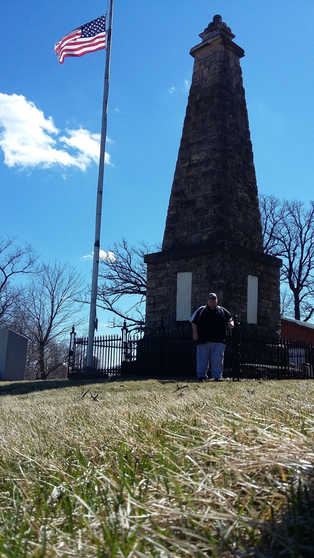
Recently, I took a mini road trip to the Kellogg’s Grove Battlesite, located near the tiny Stephenson County village of Kent (itself halfway between Pearl City and Stockton). Going up from the south, there is a lot of meandering through country roads to get there.
Kellogg’s Grove is one of two places where Lincoln is known to have played a role in some way. The other location is Stillman’s Run in Stillman Valley. At both of these places, Lincoln and his small crew were in charge of burying war dead.
The monument is accessible through either one of three gravel roads – the main trail being that of the old Kellogg Trail. It was built in the 1880s, and there is a replica (albeit rundown) log cabin nearby. A shelter and swingset are also on the grounds.
LINCOLN CAME TO KENT about a month after his duties at Stillman’s Run, in June 1832. Before he was at Stillman’s Run, he was stationed at Dixon’s Ferry in present-day Dixon.
Lincoln first enlisted in Beardstown and came up to Saukenuk (present-day Rock Island) to assist in the search for Black Hawk and his tribe. From Saukenuk, Lincoln’s men – commanded by General Samuel Whiteside (for whom the country is named after) – chased the Indians up along the Rock River. In the process, they camped out near present-day Hillsdale, destroyed the Indian village that sits in present-day Prophetstown, and camped out in a spot somewhere between present-day Rock Falls and Nelson.
When I was working for the Sauk Valley Sun, I planned a history article about Lincoln’s time marching through the area of Rock Falls. I left the Sun before it was finished, and the drafts got wiped out due to a virus on my computer. Remembering parts of what I wrote, though …
Three companies made the march from Prophetstown to Dixon along the south bank of the Rock River, Lincoln’s group between the front and rear groups. Present-day Prophetstown Road, Dixon Avenue, and Rock Island Road follow the trail in which the men went on.
I can’t remember what book I got this from at the Sterling-Rock Falls Historical Society, but according to a dot in a map from that book, Lincoln’s men camped out along the riverbend somewhere between the Howland Creek mouth and Nelson. Comparing it to a satellite Google map on my cell phone, it looks like the men camped on a spot just east of Brown’s Beach Road – now grounds of a private residence.
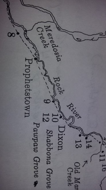
(Not sure why this picture is sideways, but No. 8 is the campsite near Hillsdale that Lincoln’s men stayed in. A historical marker hangs on the bridge rail across the Rock River on Hurd Road.
Under the “R” in “Rock River” is Como, and as the river makes its way up and over, what is present-day Rock Falls is south of the river underneath the “ock” in “Rock”. The bend underneath the “k” in “Rock” is where the private Riverview Drive is. As the river makes its way on the “c” shape, you’ll find that No. 9 settles where the river starts to go north once again. This approximate location is within the Browns Beach Road neighborhood, and in particular, on private land to the east of it.)
Dixon was pretty much already established by 1832, and 2 years later, Hezekiah Brink came departed from Dixon en route from Indiana and settled in present-day Sterling. It would be another 24 years before Lincoln came back to the Sterling-Rock Falls area, with a campaign speech and a stay at the Monahan Home in 1856.
A man by the name of Jason Hopkins was in the same group of men with Lincoln on the march from Prophetstown to Dixon. According to Bastian’s history of Whiteside County, Hopkins became intrigued with the land across the Rock River from a small hill the men had to scale. After the War, Hopkins returned to that land in which he had made a jackknife claim on. That land became present-day Como and the township it is in bears Hopkins’s name.
When I was in college, I wrote a history paper regarding the alternate history of the Sterling-Rock Falls area had Como progressed to be the town it hoped to be. Como was just as big as Sterling until the railroad bypassed it in 1855.
I have yet to visit Stillman’s Run (despite covering many games at Stillman Valley High School), but that is in the “Cards” the next time I get up there. I have also visited the Battle of Bad Axe, which was Black Hawk’s last stand until capture – this was part of my Mississippi River trip in 2012.
I made my way up to Kellogg’s Grove via Mount Carroll. I went through downtown Mt. Carroll north on Route 78 and took the first right after crossing the long bridge over the creek. That road curves quite a bit and becomes Loran Road, eventually going through the little town of Loran.
After going through Loran, there is a point near a church where you veer to the left and continue going (crossing a road called Lonesome Road) to a T, where you turn left. Go a few miles and you’ll come across a small blue sign pointing toward the monument.
It is perhaps easier to take Route 73 north of Pearl City and turn left at the road toward Kent, but I wanted to go through Loran because it looks like it hasn’t changed since 1900. The town’s side streets are all gravel and slightly uphill, and there are farmers and farm equipment all over the place.
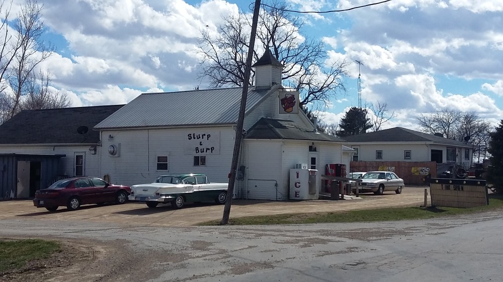
There is a bar called the Slurp & Burp. You have to visit it while you’re there.