You don’t have to go to the Driftless Region or the Mississippi River shore to see neat views. Here’s a point in northern Henry and Bureau counties with high sights, winding roads, hills to ascend and descend, and plenty of small lakes where mining once was rampant.
This is Part 3 of a 3-part series of a drive I took on March 21, 2023
| Part 1 | Part 2 | Part 3 |
| Pray the “Rollery” (LINKED HERE) | “Classic” Route 78: Hooppole to Annawan (LINKED HERE) | Henry-Bureau Moraine (you are here) |
Sometimes it’s not a singular place that catches the eye, but rather a scene that makes you go, “Whoa!”
Most of northern Illinois’ terrain from the southern edge of the Driftless Area (in the far northwest corner of the state) to the banks of the Illinois River is flat. However, there’s this one small region in the middle of what’s flat that is a little hilly with a sight of the wind mills near Manlius 10 miles to the northeast.
The photo above was taken just east of the intersection of Bureau County roads 1225N and 225E, looking toward the northeast. I’m willing to guess that on a very clear day with binoculars, one could faintly see the wind mills south of Deer Grove, another 8 miles north of Manlius.
This is part of a moraine that stretches from its westernmost point around Johnson-Sauk Trail State Recreation Area north of Kewanee to Sheffield. Lots of prairies and groves here on these hills. This “bump” came from a glacier buildup about 25,000 years ago and apparently didn’t suffer the same compressed fate that its surroundings did during the last ice age about 12,000 years ago. When Native Americans lived on the land thousands of years ago, these high points served as their first navigational routes to go from place to place. As American Colonists started to trickle into the area in the 1830s, tribes such as the Sauk, Fox and Winnebago continued to use the moraine as a major trail – which would come to be known in our generation as the Great Sauk Trail.
The United States sought to expand onto Native American territory against the will of most natives, and the British were sought as an ally to keep the new colonists out. This moraine was part of a trail that the Native Americans took to travel to Canada to receive wartime annuities from the British. Eventually, as we know, the Native Americans were driven out of northern Illinois during the Black Hawk War, and eastern settlers began to call this land home.
Since much of this land wasn’t pushed down as much during the most recent ice ages, useful minerals remained and were mined by regional companies during the late 1800s and early 1900s. Mines were scattered about the moraine, and small lakes formed where large mineral exits were dug out. As many as 60 different mining operations were scattered throughout Bureau County, and … ; some established on the same spot before or after others
The last mine in Bureau County closed in 1951, which was a small one south of Wyanet; and the last one in this moraine area within the county ceased operations in 1950. The last mine in Henry County closed in 1965 near Alpha in the western part of the county, and the last one in this moraine area within Henry ceased in 1942.
Unfortunately, the Sauk Trail isn’t very well preserved in most parts, save this stretch from Henry to Bureau counties, and a highway in the south Chicago suburbs called Sauk Trail. This trail’s overall legacy is abundant through modern transportation with 1) the Hennepin and Illinois-and-Michigan canals; 2) the former Rock Island railroad line, now operated by Iowa Interstate; 3) U.S. Route 6; and 4) Interstate 80.
Follow along
We start HERE at the intersection of state Route 78 and East State Road, and drive east. You’ll notice an old highway stub off to the right, and a historical marker to the left that tells the story of the Great Sauk Trail. Head down the road and you’ll meander around tight curves and see plenty of rolling prairies on this narrow road.
Jogs in the drive are plenty: At the first T intersection, turn right and then turn at the next left to go down another road that looks like the previous. At the next triangle T intersection, turn left and follow that road. Eventually you’ll hit another T on what looks like a county highway (rural roads with yellow striping are considered county highways, if not already state or federal ones) – this is where I’m going to detour you off the path for a little bit, so turn left at this intersection. About 3/4-mile on this county highway is a historic spot from Native American days: the Witness Tree.
At the spot of the Witness Tree was a meeting place for the different tribes that were in the region. Said oak tree is old enough to have “witnessed” these meetings. When the green oak leaves aren’t on the tree, its branches and twigs look like they meander and curve like spaghetti noodles. The picture I have in the photo album will give you a good visual of what that is. The tree itself doesn’t have any direct connection with any moment, but there are several Witness Trees around the country to serve as visual landmarks of historic events and spots – and this is one of them.
To get back to the Sauk Trail route, go back the way you came but instead of turning back onto the previous road you were on, keep going for another 1/4 mile and turn at the next left (1225N). It’s not far after that spot that you’ll see the view from the picture at the top of this post. Park on the side of the road and get a glimpse. The song that always comes to my mind at sights like these is “I Can See For Miles” by The Who.
Keep driving east down this road for more twists and hills. Go slow, though, as you’ll want to find a large stone on the left side of the road, which is about 4/5ths of a mile from the lookout point. The stone marks the site of the old town of Brawby, established in 1836 on the top of these hills. It is named for the Brawby Farmily, who continues to farm nearby. The reason why this small town – which could have been laid out so neatly within these nooks and crannies – is no more is because of the transportation innovation that was the railroad, and it just can’t go up and down these hills. When the railroad (now the BNSF) was built through this portion of Bureau County, the flatter the ground the better. Brawby was no more, and Neponset became the village that it is today.
The drive ends HERE, and at the next triangle intersection you’ll either want to go right to Neponset or straight to U.S. 34 and Sheffield.
Bonus drive: Buda
There’s a country road leading east from Neponset to around Buda, parallel to the railroad tracks. I just wandered on it to see what was out there.
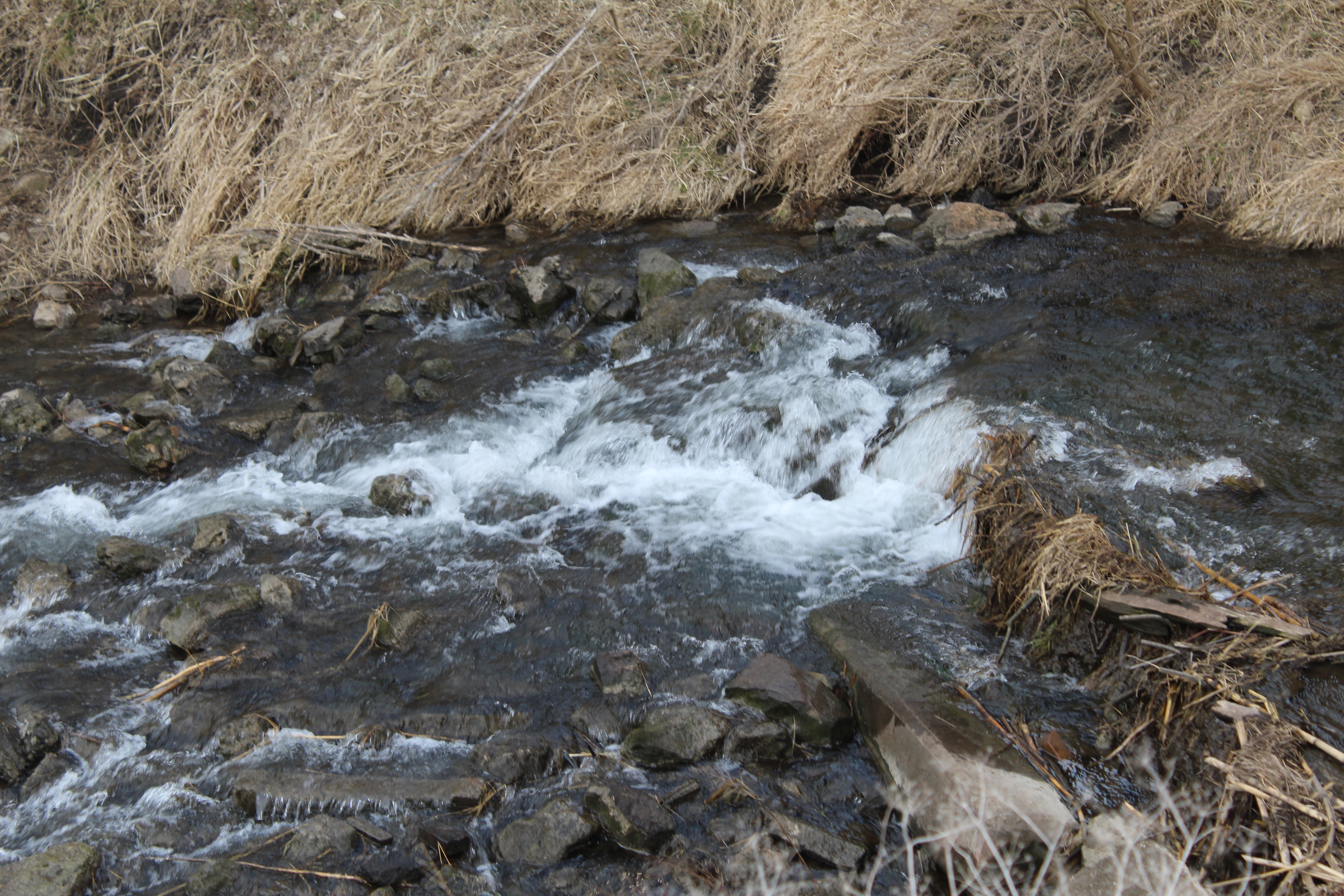
Two spots of personal interest are along county road 1140N. The first is a railroad overpass going over both another county road and the Coal Creek. The overpass is a modern one, and some of the blocks formerly used now are in the creek and create that peaceful flowing water sound – it’s like personal ASMR to me. The other spot is just east of that underpass where the railroad goes over another line, the Union Pacific line from Nelson to Pekin.
As for Buda itself, it’s a town that’s seen better days. One indicator is the town bulletin board, which is an actual bulletin board: The “Buda Buzz.” The only information tacked onto it, unfortunately, is an old town meeting schedule. Something more neat in the downtown is an old advertising mural for RCA Victor phonographs, with the iconic dog on it. The painting, while black, is fading fast.
I’ll be back in Buda for other topics and roadside thingamajigs, but for those looking for a nice scenic drive going to or coming from east of Kewanee, I recommend this path we have went on.
If this article made you learn something new, give it a “like” at the bottom at the bottom of this page.