Exploring the Elizabeth Blacktop
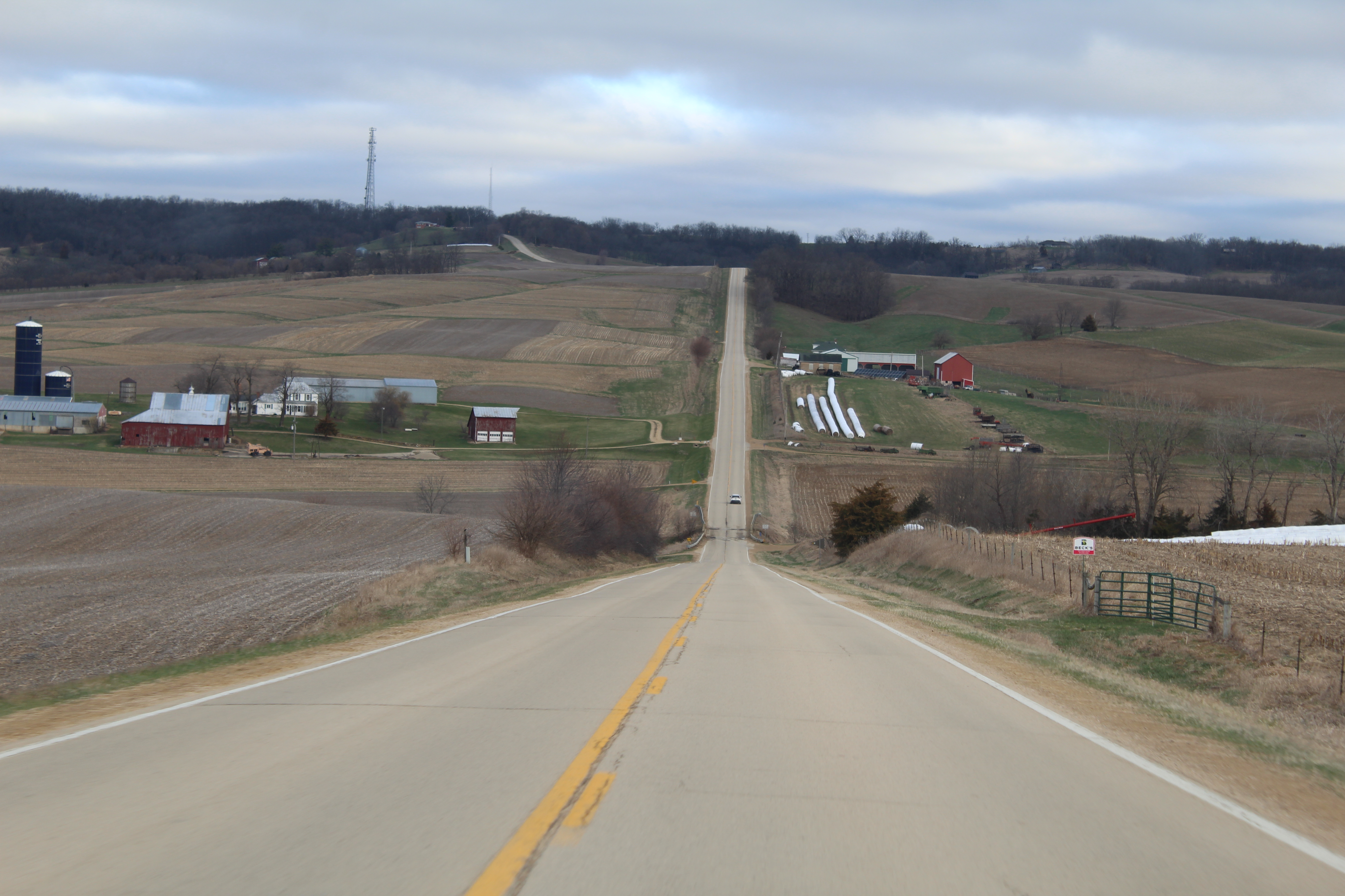
Illinois’ gateways to the Driftless Area are most notably located at the numbered highways (20, 78 and 84). One more route has much fewer cars and many more curves, a stretch that goes from Mount Carroll to Elizabeth.
The Elizabeth Blacktop is the local vernacular for a series of county roads spanning 22 miles: Elizabeth Road north of Mount Carroll, a section of Zion Road after that (which turns into Massbach Road), the short entirety of Albrecht Road after that, and then a northern segment of Derinda Road.
The winding route is a quick way to get from Mount Carroll to Galena and other points north, as well as Scales Mound and Shullsburg, Wisconsin. It’s all striped, and there are no gravel roads involved. If you enjoy views of hills and ridges that can be seen over a scope of a couple of miles, parts of this route have what you want.
The Elizabeth Blacktop’s southern terminus is with state Route 78, about 2 miles north of Mount Carroll. In this post, we’ll explore the route as we head north toward Elizabeth.
The phrase “the Blacktop” will reference the route in mentions for the rest of this post.
**** View my Flickr photo album on this drive by clicking on this link****
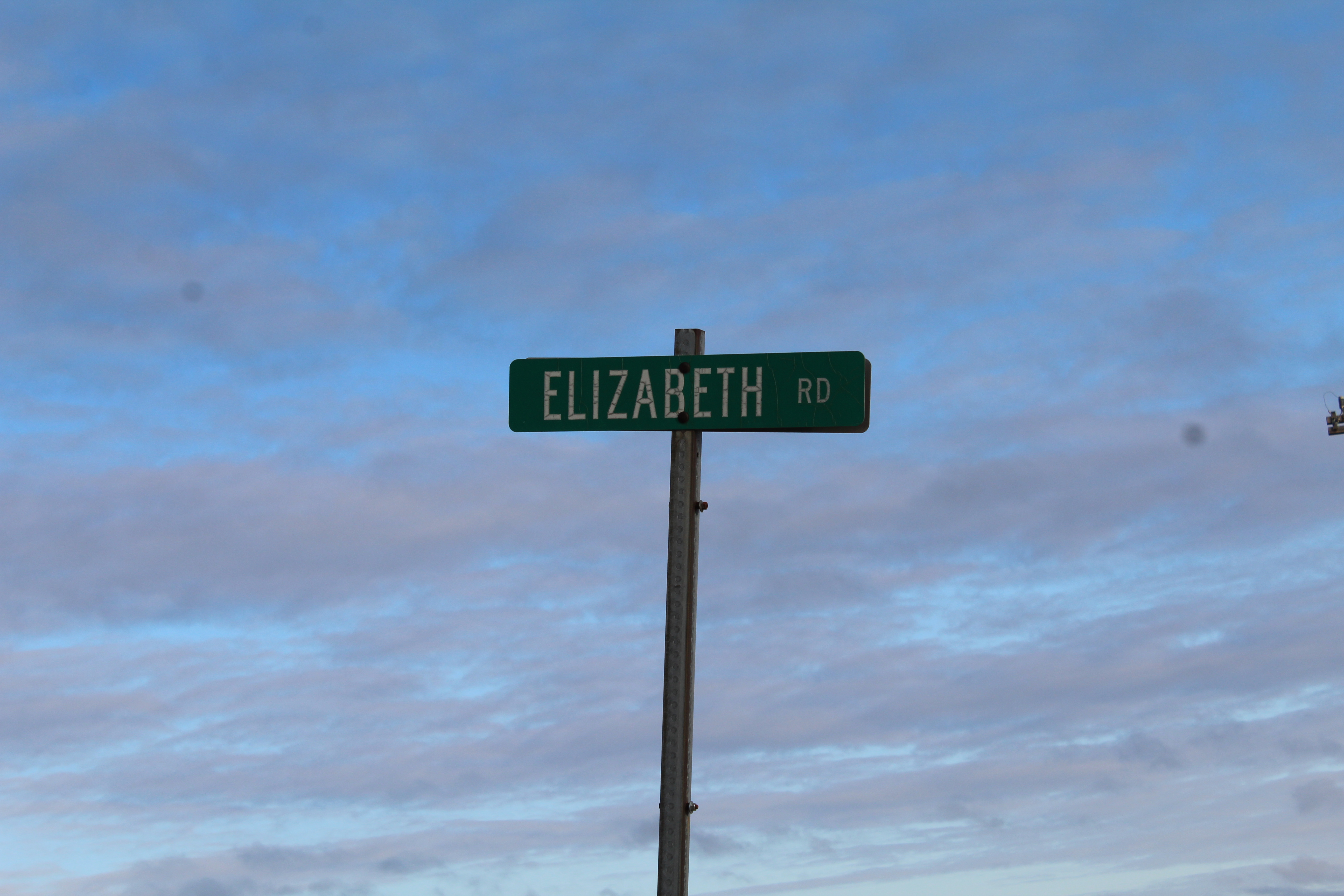
At the intersection of state Route 78 and Elizabeth Road is Strawberry Stewards Plants and Produce. The Yoder Family grows flowers from the greenhouse during the spring and fall, and produce, eggs and turkey during the summer. No chemicals are used in their growing process. Call (815) 238-1997 for more information.
The first quarter-mile along the Blacktop provides a small preview of what to expect: when the road is straight, it’s going to be either an upward or downward drive. Then there are curves, and lots of them.
Four miles into the drive, the Blacktop crosses the Plum River. The Plum collects runoff from northern Carroll, eastern Jo Daviess and western Stephenson counties, as well as water from Lake Carroll, and it flows toward Savanna and the Mississippi River. The unique feature at this bridge is the OLD pony truss bridge off to the right of the crossing. This carried a former alignment of Elizabeth Road before the Blacktop configuration was in place. The bridge no longer carries traffic, but had been in use in a private capacity for many decades.
If you stop to take a look at the old bridge, you’ll see that the drive ahead of you sends you up a hill and curving to the right. That hill originally was not there when the former alignment of Elizabeth Road was in place. As vehicles became heavier and roadways need to better accommodate them in the early 1930s, the Blacktop was created to get people from Elizabeth to Mount Carroll, and points in between, much faster. Where the Blacktop curves to the right on top of the hill, it used to run straight through it before it became a hill.

Just after taking the curve past the Plum River bridge, there is a road to the left, Davis Road, that descends downward to a former alignment of Elizabeth Road. This is a scenic spur route from the Blacktop that eventually will return to where we want to go on our way to Elizabeth. Davis Road has a narrow bridge over a creek named the Elliott Bridge, which was built in 1927. Carroll County has several old “named” bridges over small streams; many of them, such as the case with Elliott, were named after nearby land owners.
Both Elizabeth Road and Davis Road end at Zion Road. If you’re on Davis, turn right on Zion and head about a half-mile toward the intersection with Elizabeth Road. This intersection is known as Barth Corners – and that’s a name that isn’t spoken of anymore. Barth Corners appears on 1930s Illinois road maps. It has a couple of farms on it. Just north is Zion Cemetery, one of three along the Blacktop. I have a story about one of my drives through Barth Corners, which is at the bottom of this post.
The Blacktop continues north of Barth Corners on Zion Road. About one-and-a-half miles in, the Blacktop exits Carroll County and enters Jo Daviess County, and turns into Massbach Road. A vehicle weight restriction sign marks the county line. The scenery gets better from here. About another mile in from the county line crossing is a farm with buildings on both sides of the road, which I think is pretty interesting.
About two-and-a-half miles from that farm is the next turn, left on Albrecht Road. A sign pointing toward Elizabeth should make it easier to notice. Albright Cemetery is at this corner. If you don’t turn and keep going for another two miles, Massbach Ridge Winery is a destination.
Albrecht Road is very short, and when you get to the T, turn right. If, for some reason, you wish to turn left toward Savanna, that road is scenic as well, and provides neat bluff-top views of Savanna. Let’s turn right and head toward Elizabeth on what is Derinda Road – or, as I like to call it, “Deer In Da Road” (watch for deer at night).
About two-and-a-half miles after turning onto Derinda Road is Trinity Lutheran Church at Derinda Center. Like Barth Corners, Derinda Center is a location reference really only known by the locals. This old church, which has a cemetery, is unique to me in the fall. There is a small tree in the middle of the parking lot with a small bench under it. In the fall, this tree turns a real bright orange, and is one of the prettiest I’ve seen.

Just to the north of the church is a crossroads with Hanover Road. Turn left and head to Hanover and Rocky Waters Vineyard. The town hall also is located here. To get to Elizabeth, follow the Blacktop over a hill that looks like there’s a cliff to the left. The views get more scenic from here, as the rest of the Blacktop path winds on top of a ridge.
Another blue sign along the path is one for the Schurmeier Forest, which is an educational-based forest with plaques of information about what all grows there. It’s a place that I plan to write about in the future.
It’s about five-and-a-half miles to the northern end of the Blacktop. When you get to a section with plenty of houses on both sides, you’re approaching the end. The Blacktop’s northern terminus is with U.S. Route 20, and turn left to head to Elizabeth.
The total trip is 22 miles if you did it right, and maybe as many smiles at scenery as well.
Elizabeth is a neat town with a few tourist activities. That’s also another post for another day, along with a drive along an old alignment of U.S. 20 from Elizabeth to East Dubuque.
The Driftless Area only gets better the more north you go.
**** View my Flickr photo album on this drive by clicking on this link****
***
As promised, my Barth Corners story:
It was a late December night in 2009. I was coming back from covering (for my old Northern Illinois Sports Beat website) a girl’s basketball game in Scales Mound, where the River Ridge/Scales Mound Wildcats beat defending Wisconsin Class 4 runner-up Potosi. I took the Elizabeth Blacktop, and Elizabeth-Scales Mound Road, to and from. On my way back home, I get to Barth Corners and see a large herd of cattle blocking the road.
I parked my car on the road and knocked on the door of the nearby house. No one home. The only other house at Barth Corners acknowledged that it wasn’t his cattle and refused to do anything. Meanwhile, the cows finally spread out, but a couple get close to my unoccupied car. I slowly walk back to it, hop in and both roam around it. This wasn’t going to be my problem, either, but I did drive away. No other vehicle came by the whole time.

***
This is the first post on Cody’s Road Trips about a stretch of road. I have a few more planned. Maybe the format could be tweaked? I’m all ears.
