250 years of Chief Shabbona
In northern Illinois, two legendary Native American chiefs are known well enough today that their names are familiar to the residents who live on their lands today.
Black Hawk is one of them. There was a war named for the Sauk chief, born in present-day Rock Island, in 1832. Abraham Lincoln served in it.
The other is Shabbona, whose friendliness to the migrating White man is largely the opposite of Black Hawk’s.
***Click HERE for my Flickr Photo Album to follow along in this post!***
Shabbona (believed to be pronounced “Shab-uh-nay” then, often pronounced “Shab-uh-nuh” now) was a native of the Potawatomi, whose lands were around the Illinois River. Long story short, after initially resisting America’s westward expansion leading up to the War of 1812, Shabbona eventually came to respect the White man after that war. He unsuccessfully warned Black Hawk against war, and his efforts to aid the new settlers in an earlier conflict with the Winnebagoes in present-day southern Wisconsin resulted in the government giving him a dedicated piece of land in 1829 near the town that today bears his name in DeKalb County, Illinois.
As the Potawatomi were eventually swept out of Illinois in 1836, Shabbona left for a while but came back as he had not personally given up the title to his land. However, in 1847, when he was on an out-of-state visit, the government of Illinois sold it at a public auction. Shabbona didn’t learn of this until returning, and he spent the rest of his years wandering around his former territory until his death in 1859 near Seneca.
I invite you to learn more about Shabbona by visiting Roger Matlie’s History on the Fox blog. Matlie is a Kendall County historian whose subject area is where Potawatomis once settled. The Pekin Public Library also has a nice write-up.
Shabbona was born around 250 years ago, giving me a reason to take a road trip to see things about him.
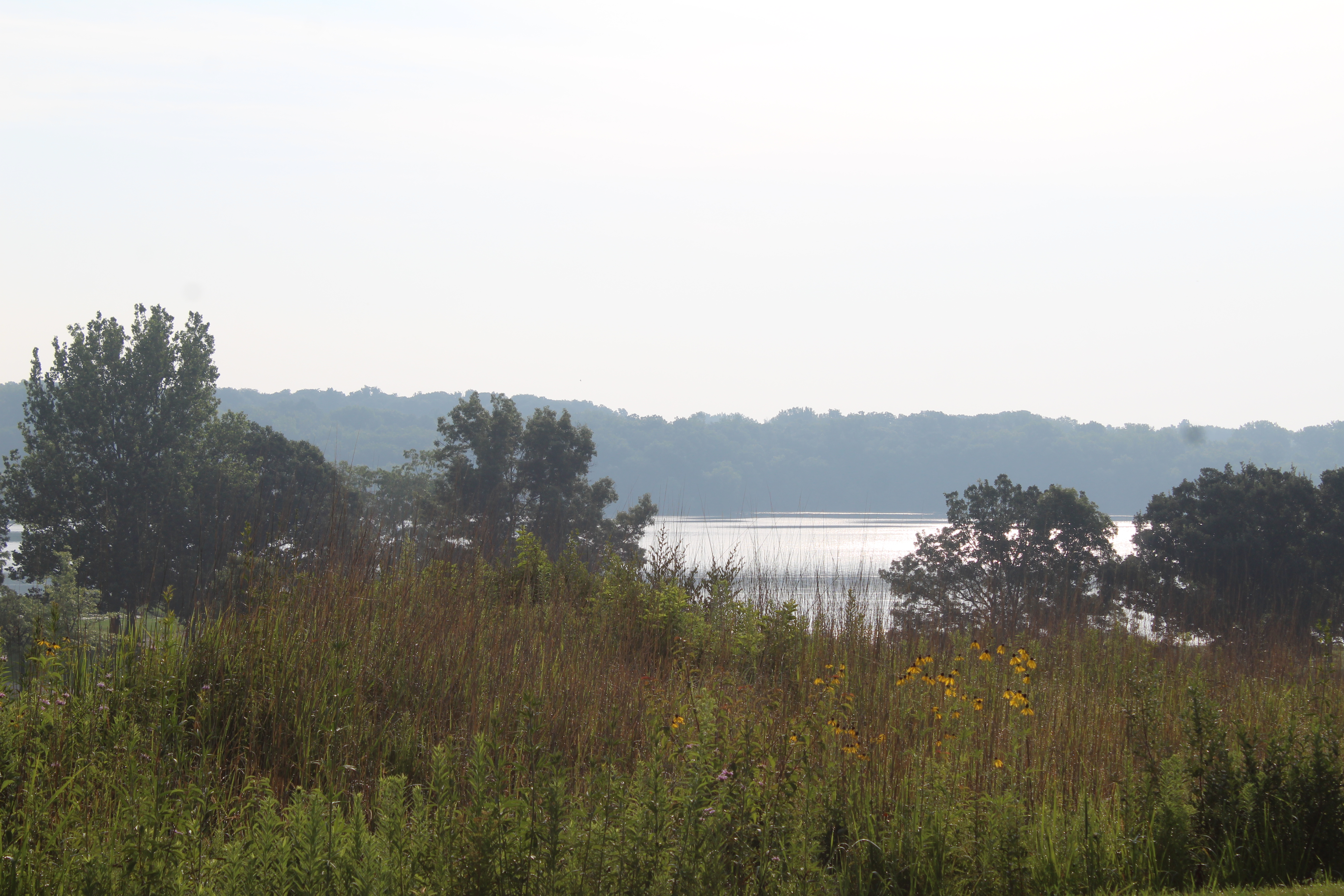
Kankakee River
We actually don’t know when or where Shabbona was born, but there are some hints. Historians have estimated his birth year to be between 1774-1776. As many Potawatomis came from British Canada around that time, his place of birth has thought to have been somewhere around there; however, a more definitive answer is revealed in Nehemiah Matson’s 1878 biography of the chief. Matson, who lived in Princeton (and once lived north of it), had interviewed him a few years before the chief’s death. The biography has his birth location narrowed to somewhere along the Kankakee River in Will County, Illinois.
Narrowing the geographical scope of his birth location – at first – could be as easy as finding the southwest corner of the county where the river serves as a border, which is around the Wilmington area. However, Will County was much larger around the time of Shabbona and Matson’s conversations, and included the northern half of present-day Kankakee County. This means the nearest present-day community Shabbona could have been born in would be maybe Kankakee? Maybe Momence? Maybe Wilmington? We don’t know for sure.
Kankakee River State Park is between Kankakee and Wilmington and provides neat glimpses of the river as it flows west. Des Plaines State Fish and Wildlife area, south of Channahon, is another place to get a glimpse of the river and is where I stopped at in this journey. The Des Plaines River is one of three rivers to converge around Channahon – along with the Kankakee and DuPage – to form the Illinois River. The Four Rivers Environmental Education Center in Channahon has plenty of natural information about that area, helping to tell the story of flora and fauna that was more prevalent around the time of Shabbona’s birth (as opposed to suburban sprawl today).
Evergreen Cemetery, Morris
Heading west from the Kankakee River, and along the Illinois River, my next stop was in Morris, which is where Shabbona is buried.
Shabbona lived a few miles west of town at the time of his death, but he did not eternally rest there. Evergreen Cemetery, on East Cemetery Road, east of Morris, is where Shabbona lies, underneath a large rock with his name and birth-death years etched on it. Other ground-level markers about his life are nearby.
The cemetery doesn’t have any signs leading visitors to the burial site, however. When coming from town, don’t go through the main gate, take the next left after it into the cemetery; then take the fourth left toward the maintenance garage, and just before the intersection next to that garage is the large stone.
Cemetery Road has a few nice scenic moments between Morris and Minooka, including the Aux Sable Aqueduct area along the Illinois and Michigan Canal, which also has a neatly preserved lock house.
Final Shabbona home site
In Shabbona’s remaining years, he roamed the Illinois River Valley looking for a new home. Some friends chipped in some resources and secured him a plot on Section 20 in Norman Township in Grundy County.
It’s a good thing that the site wasn’t described in early writings as simply “west of” or “near the river between.” Providing a section location means that today’s researchers can look at online plat maps (Historic Mapworks is my prime resource) and compare it to today’s online maps to pinpoint where these places are today.
The 30-acre site of Shabbona’s final home isn’t accessible from the road. It is on private property, but its approximate location is at the end of Dunn Road, which is near an H.B. Fuller Plant on DuPont Road, east of Seneca. There are no markers present to indicate the historical significance of the site, and exact access to it is blocked by “private drive” signs. If you look away from all of the industrial stuff, and toward the cornfield, you get a sense of what Shabbona saw on his land with his own two eyes.
Shabbona County Park, Earlville
Going northwest a ways from Seneca, south of Earlville is Shabbona County Park, 4165 East 16th Road, maintained by La Salle County. This is the location of the Indian Creek Massacre in 1832, which is considered to be an auxiliary conflict of the Black Hawk War.
When Black Hawk sought to reclaim his land in northwest Illinois, he earned the support from several Potawatomie, but not the tribe as a whole. Shabbona opposed Black Hawk’s efforts, but he realized that he could not control the Potawatomie who supported him. Upon learning of a potential uprising among a certain sect of his tribe toward the White man, Shabbona warned settler William Davis, who built a dam on the creek, that some of the natives were going to revolt about it (the dam had allegedly harmed fish supply).
Davis did not heed this warning of anti-White sentiment, fueled by the war activity going on several miles north. Several Potawatomie and at least three Sauk revolted, killing 15 and capturing two. Shabbona himself did not take part in the conflict.
The site of the Davis farm has been a county park for more than 100 years. There are two memorials dedicated to the resting places of the conflict’s dead (one built early on, and another built not long after – both look the same), and historical markers telling its story.
Shabbona’s parks and preserves
The tract of land given to Shabbona in 1829 covers the site of what is today Shabbona Lake State Park and Chief Shabbona County Forest Preserve, two separate parks located south of the town of Shabbona.
The state park opened in 1978, and features a large lake formed by damming the Indian Creek – a sense of irony about the nearby events of 142 years previous. To the east of it is the county forest preserve, which has much more shade than most places in the state park, and also features a one-way drive into the woods.
These properties either are, or are in the process of, being returned to the Prairie Band Potawatomi Nation. The public auction of the land in the mid-1800s was deemed to be illegal, giving descendants a legal right to claim it once again. These efforts led to a land transfer in 2024 of area around the preserve, and an ongoing transitional process for the state park in 2025. This land is the only one in Illinois that is under tribal sovereignty.
South of the park and forest is a small community named Shabbona Grove, 4700 S. Shabbona Grove Road. This isn’t to be confused with the town of Shabbona, which is north of the park and forest. Shabbona Grove was an early settlement that nearly disappeared when its residents and businesses moved further north to take advantage of the new railroad that came through (today’s BNSF Northern Transcon) in 1871. There are only a few houses today, and by the time a railroad did go through it (today’s Union Pacific Troy Grove feeder line) in the late 1800s, it didn’t bring back much life.
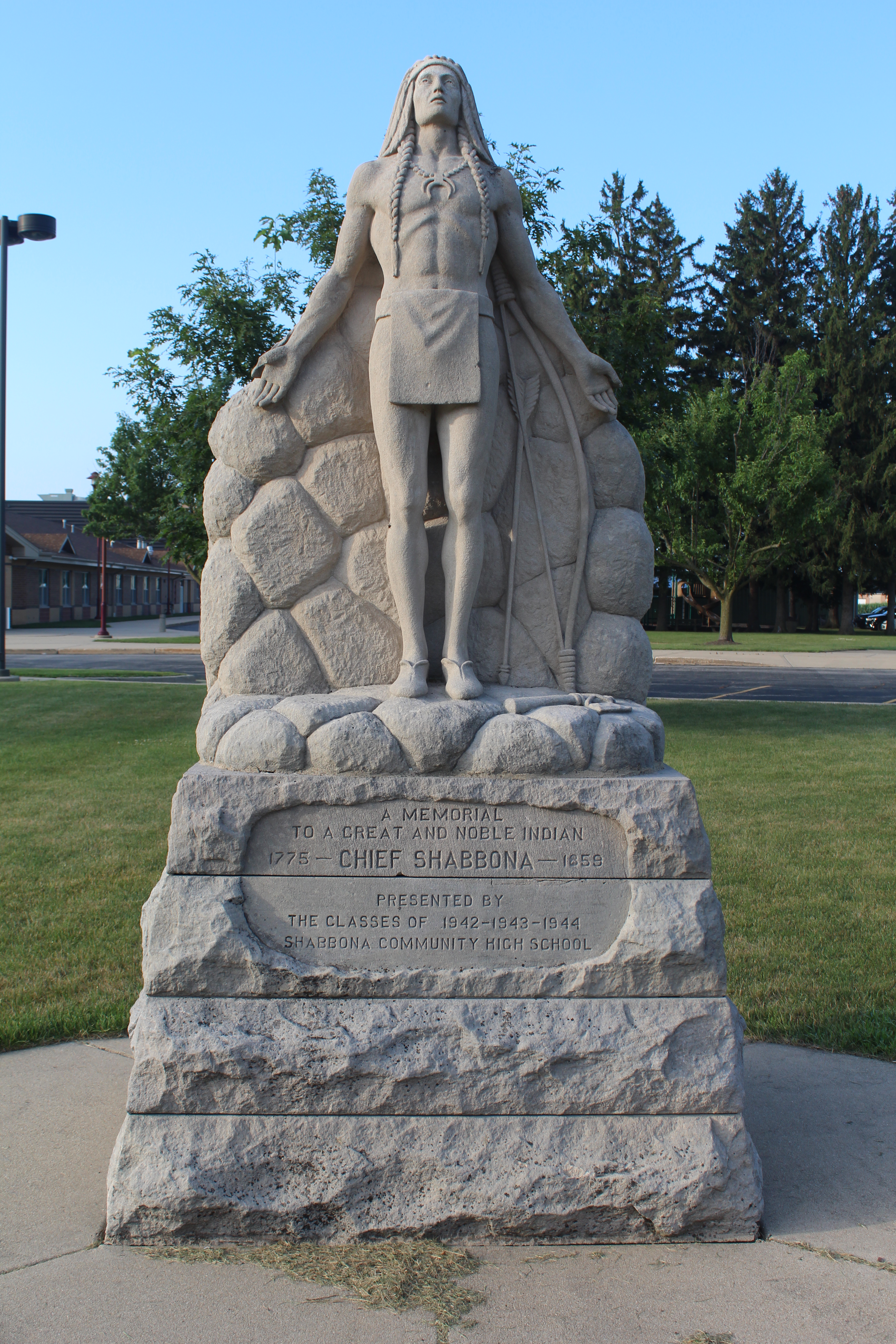
Shabbona, obviously, is named after the chief. The community has around 1,000 residents and shares its high school – Indian Creek High School – with nearby Waterman. The former Shabbona High School site in the early 20th century now is a greenspace near an elementary school at 301 W. Cherokee. A statue of Shabbona, erected by graduating classes of the former high school, stands in the middle of the greenspace. Of local interest, the Shabbona-Lee-Rollo Museum is located downtown.
Shabbona’s Rock
We conclude our tribute to Shabbona with another dive into the old plat books.
In Utica, near La Salle-Peru, there is a county history museum in its downtown. A large rock, called Shabbona’s Rock, is on its property. It was a favorite rock of his that he would sit at during his wandering years. However, it hasn’t always been there. The rock landed there having been given to the museum from a farmer near the small community of Triumph, with a section number associated with its longtime spot: No. 19 in Ophir Township in La Salle County. Today’s approximate location is along North 3859th Road, southwest of the village.
This road is now a dead-end, having been broken in two by the construction of Interstate 39 in 1984, but the donors of the rock were members of the Westgate Family, whose farm was on the south edge of the road close to the road toward Triumph. It is said that the Westgates used to bring Shabbona food and drink at the rock, where he sat and gazed into a distance at the land that once belonged to him and his tribe.
No marker or historical story at the original location tells of this being one of Shabbona’s favorite places, only recently written reminders, like you’re reading now, give evidence of it.
And it is our hope that, 250 years or so after his birth, that Shabbona’s tale continues to live on by promoting his historical locations and visual memories.
There’s more: When I went on my #Shabbona250 trip, I also went through some other towns and shot some pictures for my Flickr photo album. Included are Aux Sable, Seneca, Danway, Norway, Serena, Earlville, Rollo and a cemetery near Scarboro. Click HERE for the photo album.
