One of the most notable facts about the War of 1812 is that it affirmed that the United States was here to stay. When the British tried to weaken our country’s efforts to prosper, nearly 40 years after the end of the Revolutionary War, they failed.
A couple of weeks ago, I wrote a little about how this year marks the 250th anniversary of the beginning of the Revolutionary War (with the battles of Lexington and Concord in 1775), and how the Quad Cities had a presence in its fighting – which was unfortunate for the native Sauks who lived there.
The Quad Cities also had a role in the affirmation of our nation’s prosperity during the War of 1812.
In the years since the colonial soldiers captured the lands between the Appalachian Mountains and the Mississippi River, the territory was first the Northwest Territory, and then the Illinois Territory when the British once again came knocking. Illinois became a state in 1818.
With the United State’s presence in long-owned Native lands, cooperation was mixed. Bands under chiefs like Shabbona in the Potawatomi region around La Salle were cooperative (for the most part), and those under Black Hawk around the Quad Cities were not (for the most part). Black Hawk’s contention led to the Black Hawk War, 20 years after the War of 1812. Bands not cooperative with the United States aligned with the British, who had promised them their original territories back.
This brought the War of 1812 into the Quad Cities in two occasions. Unlike the one Revolutionary War conflict, the local Natives were victorious in these (but ultimately lost the war).

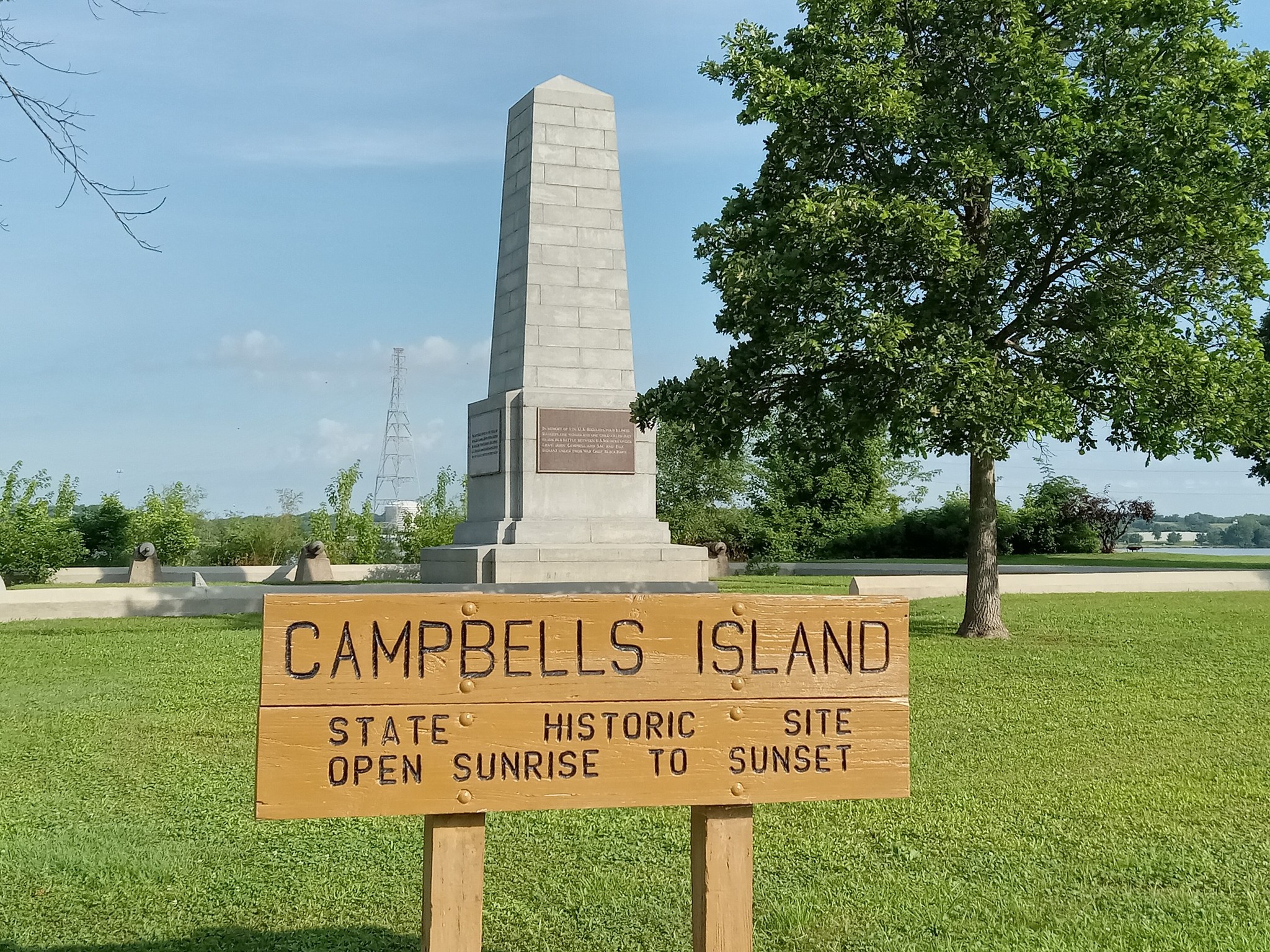
Campbell’s Island
Located along the Illinois side of the Mississippi River, Campbell’s Island is accessible from state Route 84 between East Moline and Hampton. The bridge carries people and traffic to the island, where a loop street and a few side streets have houses on them – some on stilts to prepare for flooding. There’s a marina and a church on the island, but the centerpiece of the island is the large monument dedicated to the Battle of Rock Island Rapids.
Also called the Battle of Campbell’s Island, the Battle of Rock Island Rapids saw a British-aligned Sauk force ambush an American expedition on the river en route to help at a garrison in Prairie du Chien in July 1814. The matter proved deadly for the forces under Lt. John Campbell: 14 American soldiers were killed and two civilians were as well, and 21 were injured; only two Sauk were dead.
A large memorial statue was established on Campbell’s Island in 1908 to remember the affair, with names of the dead and a history of the battle etched on it and told on affixed plaques. The statue overlooks the Mississippi River, where a couple of small cannons nearby also are faced. The sight on the opposite side of the river is not as serene; the large, now-closed Riverside Generation Station, a coal-turned-natural gas plant, closed in 2021 in Bettendorf.
While it is a memory of war, there also is a place for peace: to the south of the monument is a “peace garden” with four concrete benches, and arranged in a “Sacred Circle” design. Parts of the benches are decorated with pastel mosaic tiles similar to Sauk and Mesquakie motifs.
Very short trails lead from the grass to the river’s edge, where visitors also can go fishing. Picnic tables are across the road. Much like the next site of the Quad Cities’ involvement in the War of 1812, the place is an attraction along the Great River Road along the Mississippi River, visited by travelers throughout the world who commute by motor or bicycle. When I visited in late June 2025, there was a small contingent of bicyclists who marveled at the statue and took pictures.
Campbell’s Island originally was part of the village of Watertown, which was annexed into East Moline in 1914, six years after the statue’s erection. The Watertown Correctional Center honors the neighborhood’s former presence as its own entity.
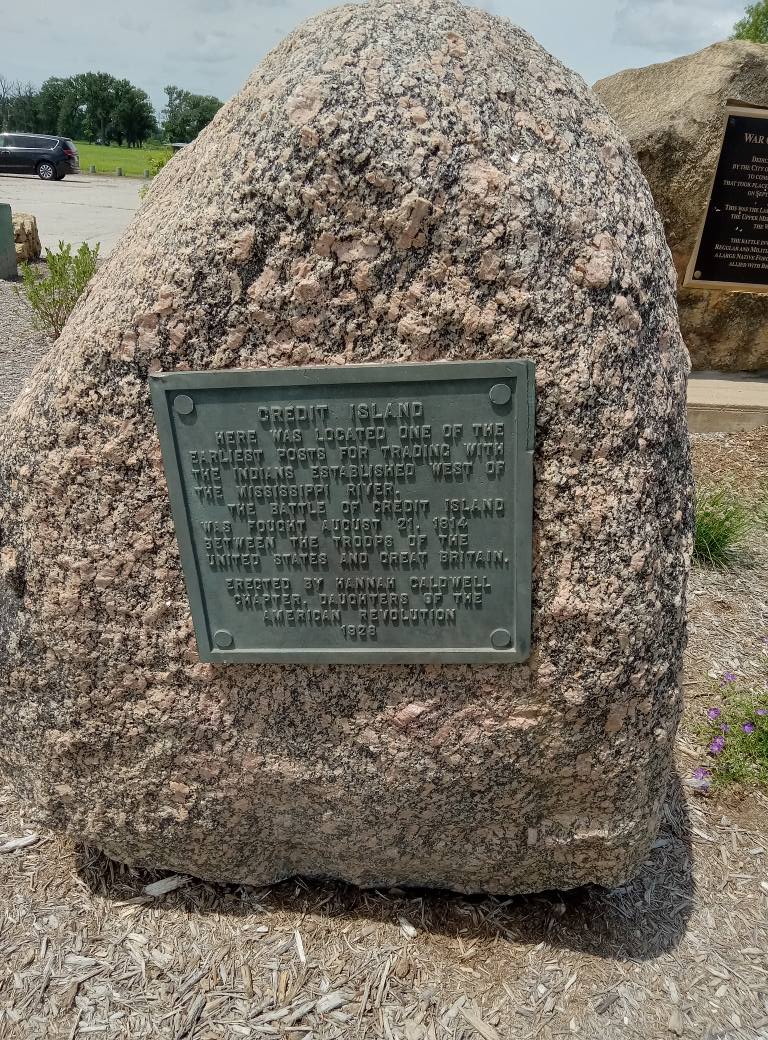
Credit Island
When we think of the word “credit” these days, it often has to do with a plastic card. In this case, Credit Island was named for credit obtained for fur trading on the island. It is on Davenport’s west side.
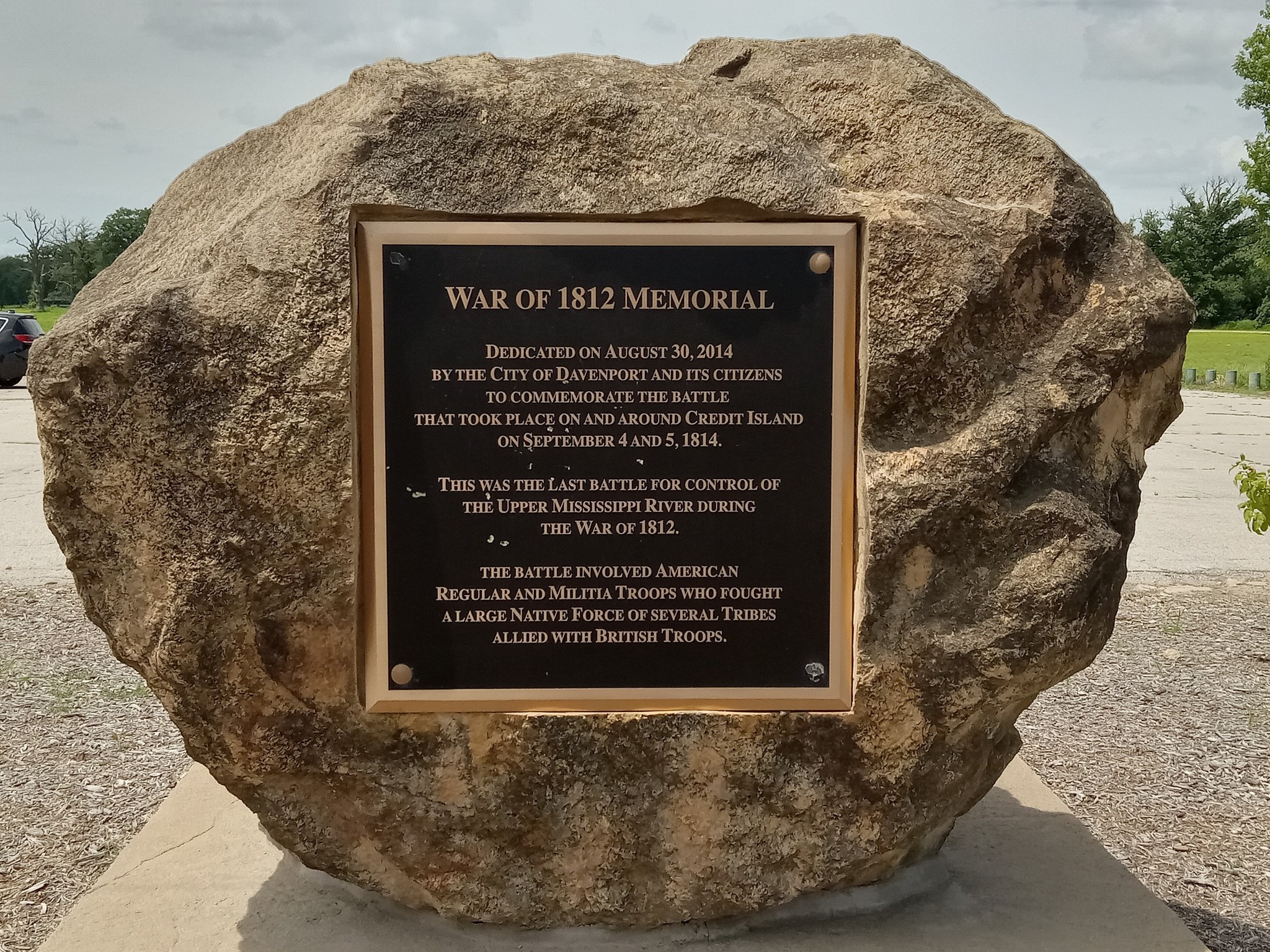
This was where another expedition to Prairie du Chien was thwarted by the Sauk and Black Hawk, this time with major and future U.S. president Zachary Taylor in command. Two rock-based monuments near the lodge denote the island’s history in the War of 1812. They look out toward the river and are across a road from a large boat launch.
Credit Island is on the other end of where the mouth of the Rock River is in Illinois, very close to the Sauk village of Saukenauk (Campbell’s Island is a few miles upstream). Two months after Campbell’s defeat, Taylor’s forces were handed the same fate even further away from Prairie du Chien. It wasn’t a significant stretch, but made it difficult for American forces to use the Mississippi to move upward. It wasn’t too long after that when the War ended without any change in control over Illinois territory.
Unlike Campbell’s Island, Credit Island is entirely a park. Both islands are around the same size. It sits low along the river that its prone to flooding often, which gives the park more of a rustic appearance with plenty of nature taking over large swaths of it. There was a lodge there that has since closed.
Something extra nearby: In the back of the park, there’s a pedestrian bridge over the river that leads to the Iowa mainland. About a mile from the bridge, walking along Concord St. and Wapello Ave. is the Nahant Marsh Education Center, which has a collection of water animals in tanks and informative displays on the marsh and vegetation. Nahant used to be its own town in the mid-1800s.
Reminders of American history are closer than you think.
Campbell’s Island State Memorial
124 Island Ave., East Moline, Illinois
Online
Credit Island
2300 W. River Dr., Davenport, Iowa
Online