Roaming around Rockford
Sometimes when you think you’ve seen everything there is to see somewhere, there’s always something different that piques your interest all of a sudden.
Rockford, Peoria and the Quad Cities (Davenport, Moline, Rock Island Bettendorf – or East Moline, depending on who you talk to) are the three closest metropolitan areas to where I live. I’ve explored them many times, but each trip seems to give me something new to appreciate.
During a late June assignment to the Rockford area, I found myself taking note of a couple of new things spotted along the way. Some of them I’ve driven by multiple times, but just didn’t stop to get a bigger picture of it. They are rather random things, but have their own interesting thing to them.
That day’s assignment took me to the Forest Preserves of Winnebago County and some of its parks, writing about them for our monthly Lake Carroll magazine. That magazine highlights some aspects of tourism that we hope interests its readers. The story was a roundup of what the preserves are all about, as well as their unique features.
Hononegah Forest Preserve, Rockton
A stop at Hononegah Forest Preserve in Rockton was a necessity, it being the first of the forest preserve district’s properties. As early as 1922, there was enough foresight to know that large, growing cities were going to one day swallow up natural areas, making it difficult for local ecosystems. The early efforts paid off as the area north of Rockford began to grow with the establishments of towns such as Loves Park and Machesney Park, and growth of smaller towns between Rockford and Beloit such as Rockton, Roscoe and South Beloit.
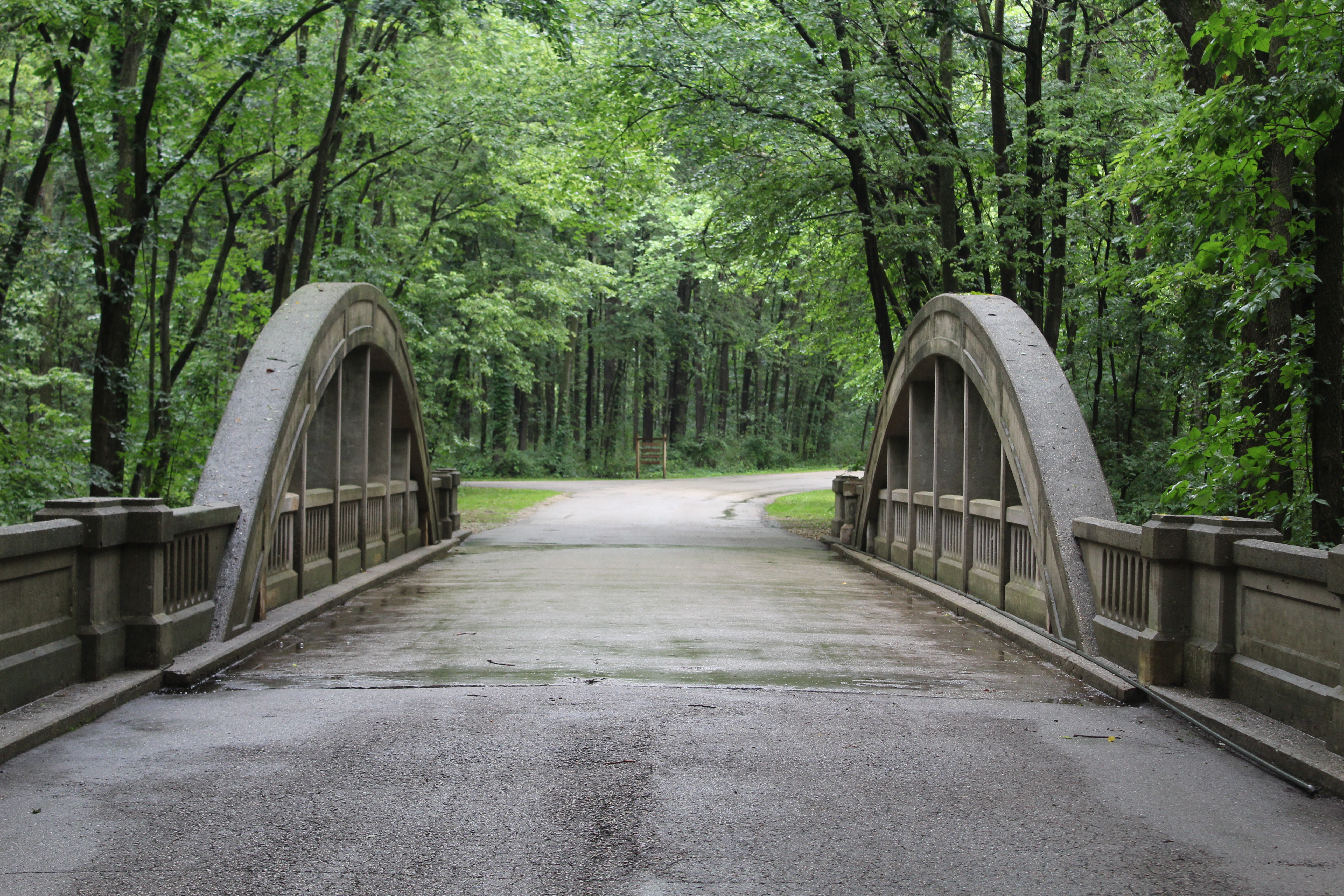
One of the pictures that I took during my visit to Hononegah was of its concrete arch bridge, which is pictured at the top of this post.
The bridge is original to the preserve’s establishment, and is used on its main road. Since the road doesn’t receive a whole lot of traffic, as opposed to a road outside of a park, it’s withstood elements and progress. More than 100 years later, it is a reminder of what art progress was like back in the day.
When it comes to bridges, my favorite shot to take is what’s called the “barrel shot,” taken as the road it is on disappears into a central vanishing point and the bridge enveloping that point. People seem to stare at it more when it looks like that, at least I do. Given the time of the visit, the leaves were perfectly green and the shade brought more focus to the subject itself and not the surroundings.
Another reason why I’m real pleased with this image is that it was taken during a light rain.
I’m not one of those photojournalists who enjoys dealing with wet elements, simply because I don’t want the camera to get wet and damaged. I’m like that with my phone, too; I get concerned that something’s going to short out or cloud the lens. However, after taking this shot, I really got to understand how the crispness of the sun’s reflection on rain drops gives the leaves some form – and not looking like a green blob of leaves.
The published version of this picture as it appears in Lake Lifestyle looks lighter than the raw image you see above. This is simply because of the printing press: unsharped masks and brightening makes it easier for the printer to make the image keep its form – so I’m told. I prefer the raw images because they closely resemble what I see with my own two eyes. It’s more reality.
Harlem
Rockford’s growth in the years after World War II brought many subdivisions and manufacturing way from the city itself, for various reasons. While forest preserves withstood the swallowing of development, some places weren’t as lucky. One of them was a burg named Harlem.
The name Harlem is familiar to locals as being the name of the township that Machesney and Loves are in, a major road going through and out of Loves, and the name of the school district for both towns. Before all of that, however, Harlem was the name of a railroad crossing with a road. This spot today is around the northeast corner of Harlem and Forest Hills Roads.
While the road is still there, the railroad is gone. It was the Kenosha and Western, which connected Rockford with Lake Michigan in Wisconsin from 1861 to 1939. It was acquired by the Chicago and North Western in its later years. Paulson’s Agriculture Museum in nearby Argyle has a model railroad setup in tribute of this line.
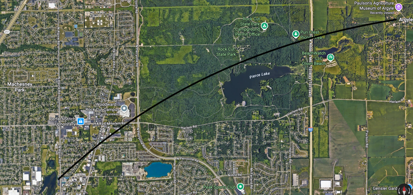
While the drawn line is not approximate in this map screenshot, it provides a general path of where the rail line went. Next to Woodward’s Rock Cut Campus is the word “HARLEM,” which is at the intersection of Harlem and Forest Hills. Pierce Lake at Rock Cut State Park actually sits on the right of way, and I’m told that there are still steel rails at the bottom of the lake.
With no railroad, the small community dried up and was absorbed by growth. What survives of the burg of Harlem today are two streets (East and Henry) and a couple of houses. Woodward has a disc golf course for its employees that enters part of Harlem. There is also a historical marker at the corner of the busy intersection that shares the burg’s story. One of its churches also survives and is now The Ark Church near Harlem and Alpine roads.
To the historically-challenged, they might wonder why someone decided to put a small community at such a random spot. Little do they know that a railroad once ran on that path. Traces of the Kenosha and Western right of way are visible near Argyle, and south of Harlem.
Beef-a-Roo, Roscoe
When local business chain pay tribute to local history, it’s a cool thing for this road tripper to see.
Beef-a-Roo is fast food chain in the Rockford area, and also has a new location in Freeport. There used to be one in Sterling when I grew up, but it closed long ago. The Roscoe location (which it calls its “Roscoe Station” location) on the northwest corner of state Route 251 and Hononegah Road, pays tribute to the town’s rail history: the Chicago and Northwestern once went through town on a line between Beloit and Belvidere (which eventually went all the way to Spring Valley by the Illinois River at one point). This line and the aforementioned Kenosha and Eastern crossed in Caledonia in Boone County.
The sign out front is designed in a Chicago and North Western style. The building is a replica of a train depot that was in West Baden Springs, Indiana (itself is next to French Lick – home of Larry Bird and a large vacation resort). The interior is cavernous like a depot of its size was. Plenty of railroadiana and images of engines and depots of local towns adorns its walls. It’s the simplest thing to a local train museum.
Even the Chicago and North Western is no longer, bought by Union Pacific in 1995. Their familiar bright yellow and dark green engines have faded from the rails in recent years. Kudos to places like Beef-a-Roo, and Paulsen’s, for keeping the local railroad history alive – and that of Harlem’s.
Fairgrounds Park, Rockford
This and the next place are two places I know about, but stopped by to see what was happening at those places.
Fairgrounds Park in Rockford is where state Route 70 (Kilburn Avenue) and Business U.S. 20 (Jefferson St.) meet. As its name suggests, it was a fairground at one time. For lovers of old baseball history, it’s where the Rockford Forest Citys (no -ies here) played their games in the late 1860s and early 1870s. It was simply an amateur team in the 1860s, but achieved professional status in 1871 as part of the National Association.
Early ball players of the Forest Citys were future Hall of Famer Albert Spalding and one of pro baseball’s first (and very forgotten stars) in Ross Barnes. If the last name Spalding sounds familiar, it’s the same guy who founded the sporting goods company later in his life. He and Barnes later played for the Boston Red Stockings, which became one of pro baseball’s first dynasties (the Yankees of their time).
Spalding was born in nearby Byron and moved to Rockford as a kid. Barnes was born in Mount Morris, New York (in fact, Macmillan’s “The Baseball Encyclopedia” erroneously has Barnes born in Mount Morris, Illinois, which is a few miles from Byron). Barnes was a five-tool player who led the National Association in several categories, but his career was a short one. If he had played 10 years, he would definitely be a hall of fame, but the current rules of Cooperstown make the 10-year thing a requirement.
Fairgrounds Park has plenty of open green space, and one can play a game of baseball there today.
St. Thomas Catholic High School building, Rockford
Looking over Fairgrounds Park to the south is the former St. Thomas Catholic High School building. It once was Rockford’s Catholic school for boys until Boylan opened in 1962. This building went through several changes in the years since, and I think only a single office suite is its lone activity in this elaborate building.
The small drive next to St. Thomas’ former front entrance is merely a service drive today, and a Salvation Army building blocks its view of Fairgrounds Park. The building’s front entrance also is sort-of sealed off, having become a small loading dock, but the school’s name above it still remains. A shrine to the east of the building is gone, only its shell remains.
I make it a point to drive by when I’m in that area of Rockford just to see if the building is still there. Some of the glass windows are broken. It still stands, unlike Rockford’s former Catholic girls school, Bishop Muldoon (just a couple of blocks away), which was razed about a decade ago and is now the site of a clinic.
Learn more about St. Thomas by visiting its page on Illinois High School Glory Days.
