This year’s Fall Road Trip (2025) was traveling the entire length of one of Illinois’ longest state highways: Route 1.
Illinois Route 1 traces a path far older than the pavement beneath it, largely following a historic trail linking southern Lake Michigan to Fort Sackville in Vincennes, Indiana. The corridor was strategically important before and during the Revolutionary War, giving the British access from Canada into the interior via the Wabash, Ohio, and Tennessee rivers after their 1763 victory over France. As Indiana developed earlier than Illinois, this route became one of Illinois’ earliest heavily traveled corridors. When the state highway system formed in the late 1910s, the historic connection fittingly became Route 1, now stretching 323 miles as the state’s longest original highway.
The trip took 5 days. In this entry, I highlight Days 2 and 3 in this Part II of III trip log. I began Day 2 in Danville and went down to Vermillion, and back to Danville. On Day 3, I duplicated my Day 2 path (caught some pictures I missed taking the previous day) and headed south past Lawrenceville – which is the town this log will stop at.
The Champaign News-Gazette recently published a series of in-depth articles about Route 1 in and around Vermillion County. Click HERE for an index of history and current news along the route.
Click here for a trip preview
Part 1: Log – Album (covering Chicago to Danville)
You are here —> —>Part 2: Log – Album (covering Danville to Lawrenceville)
Part 3: Log – Album (covering Lawrenceville to Cave-in-Rock)
***There are way more photos I took along this stretch than the ones you saw when you clicked the links on this page. Click HERE for the full Part II photo album and see more things that I didn’t describe in this trip log!
Flying through Danville
At just a hair under 30,000 residents, Danville is the largest city, save for Chicago, on Route 1. Many motorists know it as the first or last time after or before crossing the Illinois-Indiana state line on Interstate 74, but we’re not traveling the freeways – rural highways will do just fine.
At the east end of Swisher Ave., where it Ts with Route 1 is a two-story house with white bricks that would look like just a house most months, but was decked out in October with large Halloween decorations. The displays were in tribute to Danville native and recently-turned-centenarian Dick Van Dyke, with some of his movie roles depicted.
The Vermillion County Museum, closed on the day I visited, has history from Abraham Lincoln connections, an old school room from the turn of the 20th century, and coal mining history as it was a big industry in this neck of the woods. The outside has a metal sign with reliefs displaying Lincoln, who is well known; William Fithian, a politician and friend of Lincoln’s; and Joseph Cannon, who was Speaker of the U.S. House of Representatives from 1903-1911. Even when the museum is closed, there’s still history to take in: A millstone from the town’s first mill, on the Vermillion river, also is on outdoor display, as well as a Looking for Lincoln informational marker on his connection with Fithian.
This will have to be a visit on a return trip, as well as the rest of Danville – as I didn’t want to get too involved and miss out on planning along Route 1.
Other markers close to Route 1 include one where US 150 crosses the Vermillion River noting the extent of Lincoln’s 8th circuit law practicing territory, an A-7 Corsair II military airplane maintained by the local VFW next to Victory Monument Plaza, and the Victory Monument itself – a Lorado Taft sculpture large and looming over the Intersection of Routes 1 and 150 memorializing those locals killed in World War I.
Towns as large as Danville have collar communities that surround it on multiple sides. All of Danville’s, though, are south of town, one right after another along Route 1: Tilton, Hegeler, Belgium, Westville and Midway. Between Hilton and Hegeler is some land considered to be part of Danville, and it, too adds to Danville’s passion of supporting the military. It’s actually a burger place: Gross’ Burgers.
(A 15-photo spread of Gross’ Burgers begins at this link.)
Don’t misread that: Gross is the name of the family who owns the restaurant (an order-here and carry to your table place), and they have a long family history of serving in the Marines. Several artifacts of everyday military life and pictures of the family are found throughout the place. This was my early lunch, and the burger was fine. A pizza burger and mozzarella burger also are on the menu. The apt pairing of the words Gross and burger isn’t lost on the place, as bumper stickers inside read “I ate a Grossburger.” The kidding aside, making it a place that is military-friendly is a great thing. (I actually ate there on a family road trip, when I was a kid, about 25 years ago when we visited Indianapolis Motor Speedway and the James Dean Museum in Fairmount.)
Georgetown to Ridge Farm
An area all within one school district, Georgetown is the next major town south of Danville on Route 1.
A piece of everyday school history in towns with a large major highway through it remains unused, but in sight to remind people of what crossing the highway was like. This is an underground walkway from one side of the street to the other, which once led to the Frazier elementary school. The school is gone, replaced with a Dollar General. I once saw one in Odell on U.S. Route 66, and it reminded me of that.
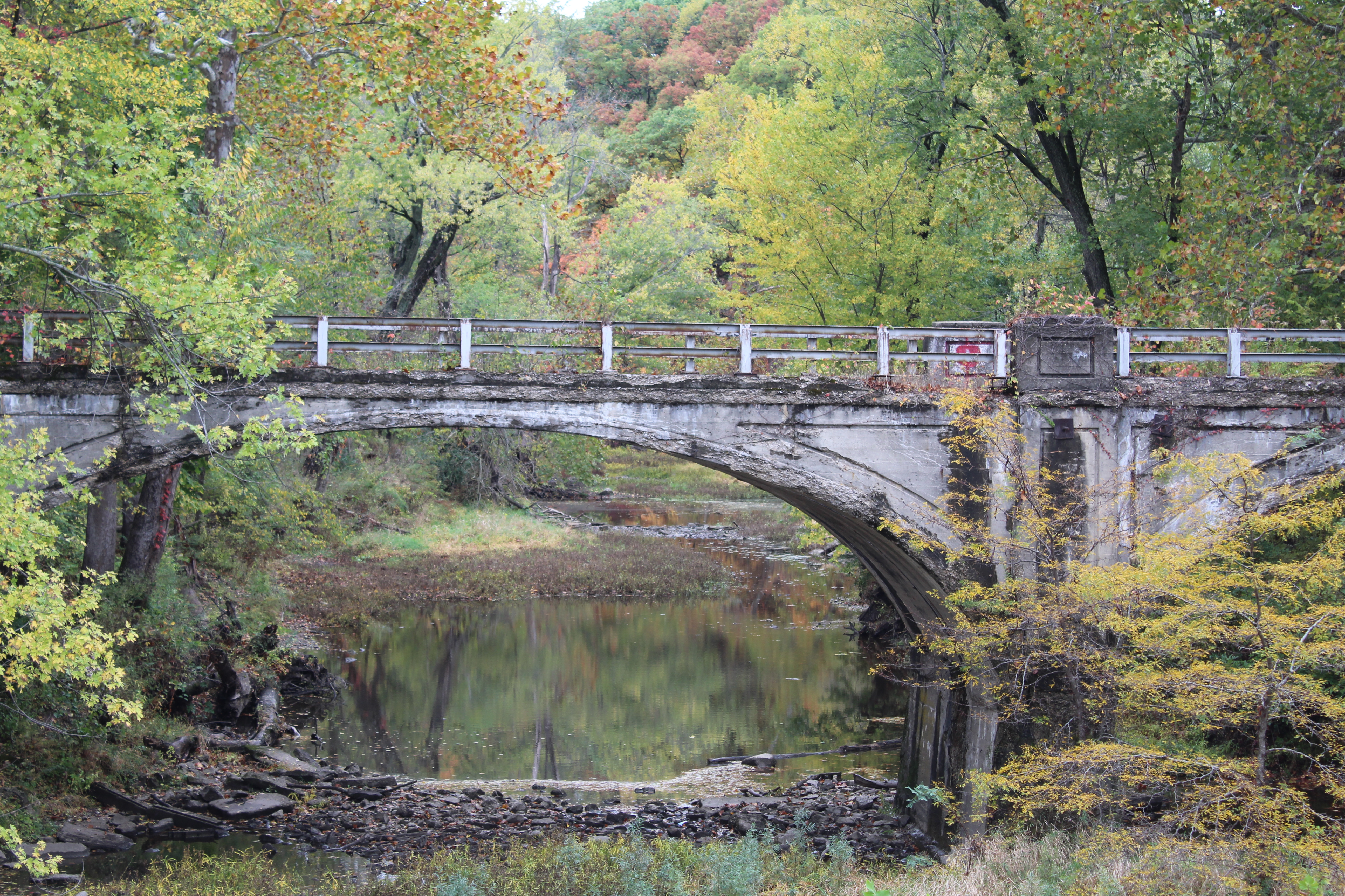
Traveling in the fall has its scenery perks, especially with all sorts of leaf colors. If you find a great backdrop with an open surrounding, it provides a great opportunity to take in a lot of color and surround it in a frame. The photo gets even better if there’s something old in the middle of it … and crossing the Little Vermillion River (not to be confused with the main branch to the north), there is an old Route 1 bridge to the west of it with wide arches. The old paint-faded bridge, surrounded with fall colors and a stream with algae made for a great picture.
Olivet is the next town, and it’s a name more associated with a private university in Bourbonnais, next to Kankakee. However, the university began in this small town of Olivet and was there until just before World War II. The town was established when the university was founded there in 1908. It moved to its current home in Bourbonnais in 1939 after a fire destroyed its main building. The campus remains a place of education, now home to the Notre Dame de La Salette Academy all-boys boarding school. An Olivet Nazarene church also is in town.
Another old school long gone is in Vermillion Grove, southeast of Olivet and a mile west of Route 1. The town is home to a quaker church that was established in 1822 (and rebuilt some time after the 1850s, see Mann’s Chapel). The village also was home to the Vermillion Grove Academy from 1874-1932, which offered high school-level education. A bell remains from its history. I noted that for updating on our Illinois High School Glory Days page on the school.
In Ridge Farm, I also took an updated picture of its old high school building for the website. One of the first things I noticed in town is a yellow IDOT sign with a golf cart on it, illustrating to motorists to look out for golf carts. The illustration shows a golf club sticking out from a bag in the back seat. I thought it was interesting considering that there isn’t a golf course for miles in this town.
Ridge Farm’s connection to American territorial history lies in a historic marker a couple of miles east of town. This is a western border mark of the 1809 Treaty of South Bend, which ceded much Native land to the federal government, including a large swath of eastern Illinois – leading to the Illinois Territory and Illinois’ eventual statehood 9 years later. It was negotiated by William Henry Harrison, 32 years before he became our 9th President. The marker reads: “The treaty between Harrison and the Indians signed on this spot in 1809. Erected by the Woman’s Club of Ridgefarm Illinois 1927.”
More Native-related history is told a few miles south of Ridge Farm at a rest stop; this one telling the story of the Pontiac Peace Treaty during the French and Indian War in the 1760s (itself a stage of the Seven Years War between France and England). The marker is actually a few miles east of the actual spot it happened at, but placing something along Route 1 attracts more people to learn the history. The historian in me wants to see the actual sight, perhaps I can imagine the scene with what I see.
Chrisman area
As mentioned in Part I, Chrisman is where the Dixie Highway turns away from Route 1 and heads toward Indianapolis (on U.S. 36) and its eventual end destination of Miami. I noticed two interesting things in Chrisman. One was a large mug of root beer – actually, a large cylindrical sign designed like a mug full of root beer at the Frostop Root Beer Stand. I enjoy root beer and is the only kind of soda that I plan to limit myself to as I start cutting back on it. The place was closed when I drove by, but it was neat to see such an interesting sign. Another underground school crossing tunnel is in town, and this one is still in use.
I decided to travel a few miles east and west of Route 1 on U.S. 36 because there were a couple of old high school towns: Metcalfe and Scottland. I took some pictures of historical reminders of the high schools in (both) (towns). Both high school buildings are gone, but the gym in Scottland is still there, and has an interesting story to its current use. One interesting sight along 36 between Metcalfe and Chrisman was an old motel converted into mini storages; the vintage Town ‘n Country Motel sign is still standing.
The REAL reason why I detoured over on 36 was to stop at the Ernie Pyle World War II Museum in Dana, Indiana, which is about 10 miles east of Route 1. The museum will be covered in its own post at a later date.
Paris (Illinois, not France)
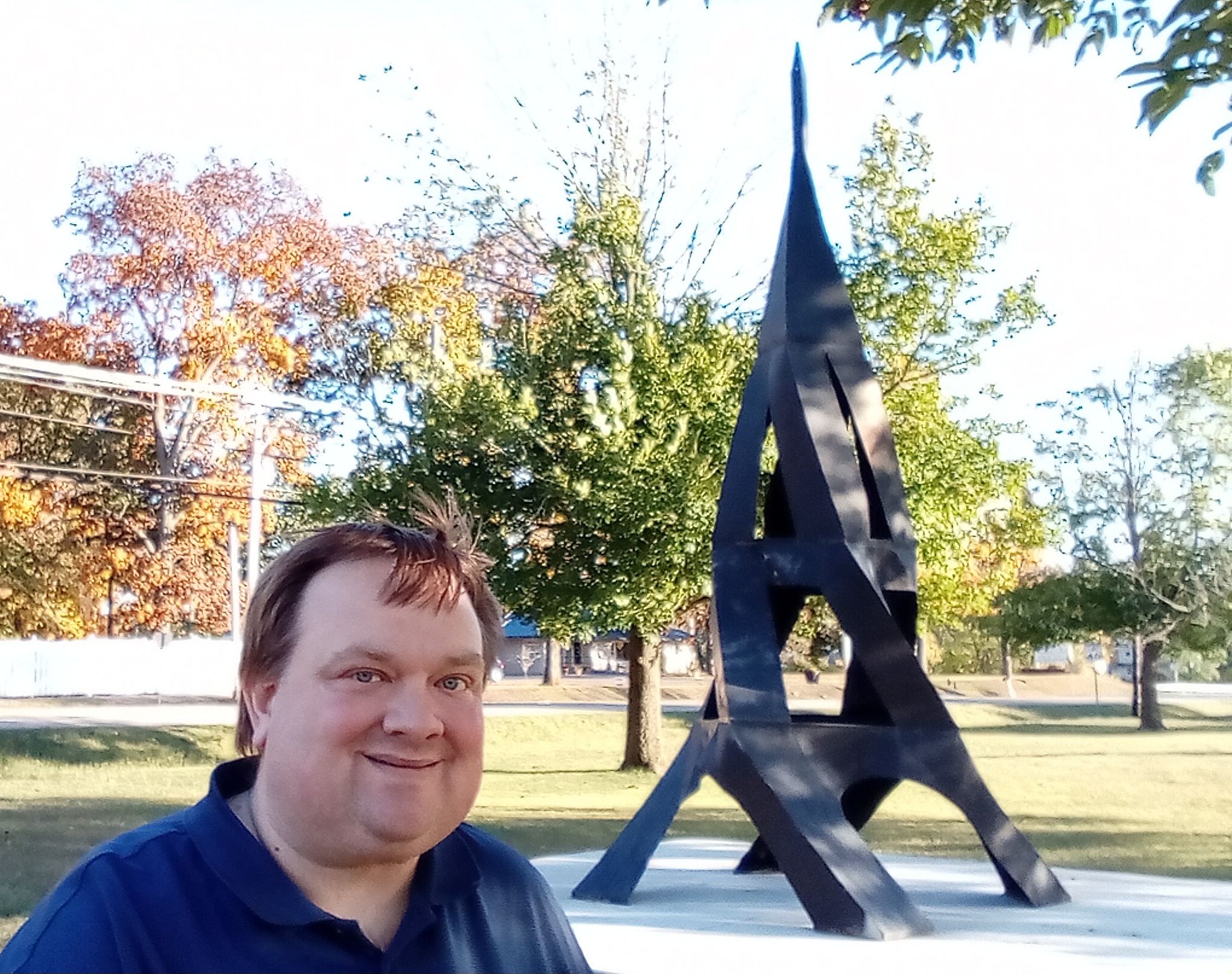
Paris is the second largest downstate Illinois city, behind Danville (“downstate” meaning south of the Chicago area). The “jokester of an international traveler” in me can now add Paris to the list of “international cities” I’ve visited. It even has an Eiffel Tower. Sort of. At Kiwanis Park on the north end of town, off of Route 1, is an iron-based piece of art resembling the famous French tower.
The town’s former Dollar Video building is now a Dollar General. Nothing quite unique about that, but I keep noticing that with these former Dollar Video buildings that its familiar tall lighting posts remain at some of them. Paris’ is no different.
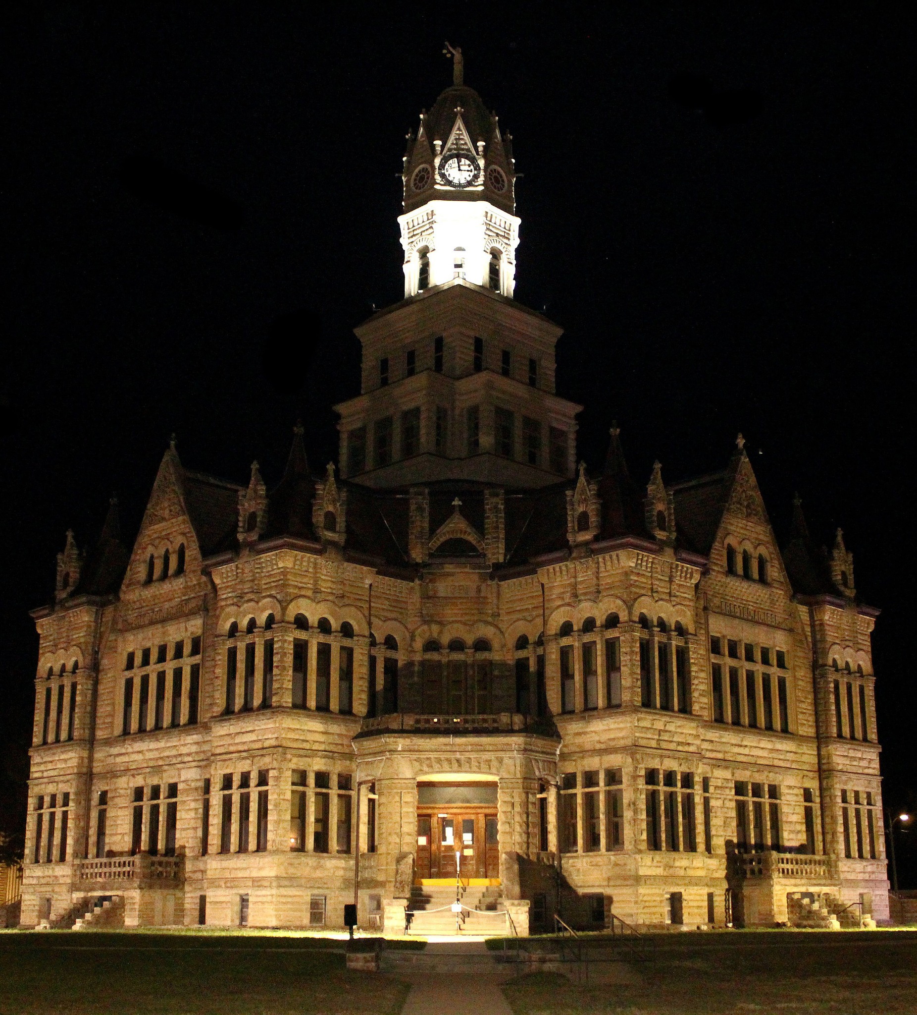
Driving into town, I became marveled at the stately Edgar County Courthouse building, which takes up an entire downtown block. Courthouse buildings are meant to be unique and stately, particular with those built around the turn of the 20th century. After seeing that, I immediately thought it would be a great night shot photo try. However, there was still sunlight left. I burned some time by wandering off the beaten path to the town of Vermillion and returned to Paris to have dinner before taking a chance at a good courthouse night shot. (More on Vermillion in a moment.)
The place in Paris I ate at was The Old Glass Shop. As the name implies, it was an old glass shop for decades before becoming a restaurant. The building is shaped like a wishbone and looked like an old garage at one time. The exterior has been modernized, and the place also sells bait and packaged liquor, as there is a small lake nearby. The bait and beer area also has the shop’s old cash register on display.
With darkness now in full effect, I made my way back downtown. First, I stopped at the OLD Paris High School, which has been converted into apartments. The front of this building has a real New England academy look to it, and lights illuminate its entrance. The school moved to its own larger building on the north end of town about 15 years ago. The old building’s annex is the Ernie Eveland Gymnasium, home to many great PHS hoops teams over the years.
Now to the courthouse. When illuminated, these kinds of buildings show off their true majesty, there’s nothing around it to distract the eyes since its mostly dark outside. Courthouse architecture wasn’t really anything I thought of until seeing the octagonal Pike County one in Pittsfield last year (and I wish I would have taken a night shot of it, especially since my hotel was across the street). Entrances are on all four corners. I just happen to live in a house that has a sidewalk leading to a corner at a 45-degree angle and taking a picture of my front door results in several angular outlines. So I decided to do the same with this courthouse, and the end result (after some editing) is what you see at the top of this page.
Vermillion
The road from Paris to Vermillion, a town not on Route 1, is called Sulphur Springs Road, and traveling on this stretch is enjoyful if you like fall foliage. It was sunset when I meandered down this road, and I caught an old Italianate brick home off in the distance, and with the way the sunlight was, it seemed like a neat photo to take.
Vermillion is another one of those downstate Illinois towns that has seen better days. However, it’s old store building still stands, AND has a vintage Coca-Cola advertising mural on it, albeit a little faded. Gotta love it when there’s still something to see on an old building like that. What was also interesting about it was that an early 2000s Coca-Cola vending machine was still next to the front door, but it was broken.
Another interesting sight in Vermillion is the old power station for the Terre Haute, Indianapolis & Eastern Traction Company interurban rail line. The company is long since gone, but its power station sits abandoned. So abandoned, that it’s possible to walk inside of it and see weeds growing around it.
Paris marked the end of my Day 2, and Day 3 was spent exploring Route 1 south of town. One of the first things I saw was this large American flag at Forsythe Family Farms near the small town of Oliver. I don’t know the actual size, but you could take a guess from looking at the picture I took. It’s larger than one you would typically see at a Perkin’s restaurant, and that’s all I know. The place also is a family fun ag destination.
Marshall
Two historic roads cross in Marshall: the Vincennes Trail and the National Road (U.S. 40). The National Road goes from Cumberland, Maryland to Vandalia, Illinois, and was the first “modern” trail going west from the original 13 colonies. I visited the end of it in Vandalia a couple of years ago. As the crossroads of a pair of early trails, it serves as the Clark County seat. That’s where I visited the World’s Largest Gavel. The World Record Academy website has it as “61 inches in height, 36 inches in diameter, and 16 feet 6 inches in length.”
Why does Marshall have this huge gavel? Much of the inspiration has to do with a town about 10 miles west, Casey, home to many “World’s Largest” things, and a unique way to attract tourists. Casey will have to be a place I will need to visit at some point, as veering off would have caused a dent in my itinerary. There are a lot of places I discover on these trips that I save for future trips.
Marshall having the large gavel also is noteworthy if you’re familiar with early American history. John Marshall served as the longest chief justice of the Supreme Court, from 1801-1835, and the town is named after him.
Wabash River towns
It is south of Marshall where Illinois’ border with Indiana turns from being on fields to the Wabash River. Route 1 either goes through old river towns, or is not far from them. As the Wabash empties into the Ohio River, and the Ohio flows into the Mississippi, the river was Indiana’s gateway to the Gulf of Mexico, and travel and commerce mattered greatly there in the mid-1800s.
The first such town was Darwin, a few miles east of Route 1. It was home to a ferry across the Wabash that was in operation for more than 200 years. A mural of it is on display on a farm building along Route 1 near Lincoln Trail State Park. (Route 1 runs concurrent with a leg of the Lincoln Heritage Trail). The ferry began service in 1818, and the actual ferry was replaced several times until early 2020, when it sank. I assume the coronavirus economic downturn sealed its fate. A historic marker about the town sits next to an old community building, and the entrance to town has a small sign (apparently unchanged since before the ferry closed) which reads its population and some more info.
West Union, West York and York were other towns I explored. The first two had high school buildings, the one in West Union is gone but a small annex is now a community center; the one in West York is now a home. West York was settled after York, and it sits atop a bluff. The original York used to be a lot bigger, but floods over the years caused many residents to relocate uphill. The two towns are about the same size.
Approaching Lawrenceville
The end of the Vincennes Trail is near, as Lawrenceville is across the Wabash from Vincennes. Before going into town, there were four more small communities to explore.
Hutsonville was the largest of the three, where I saw a house with a unique battlement-style corner, as well as the Hutson Cabins historic replica village. Hutson Cabins is open on Sunday afternoons during the summer and shows off what pioneer life was like in the town in the mid-1800s.
Flat Rock is home to the Maxwell House Cafe, which I do not believe has any direct affiliation with the coffee company of the same name. I think?
Birds was another one of them … and the use of the word “was” may one day hold true, as most of the town looked real abandoned and run down like a tornado went through it. There’s still a church in town. All of the streets are named after birds, and thinking about the birds and all of their colors is a visual escape from looking at the actual town. Sorry, Birds.
Pinkstaff is a lot better. The small town is home to a whiffle ball league, and it even has its own whiffle ball field. It’s great to see something like this in a small town, and it’s the first time I had ever seen a whiffle ball league. It has its own Facebook page.
I’m ending this Part II log here because, as you have read, there was a lot to cover. Part III goes from Lawrenceville to Route 1’s end in Cave-in-Rock.
***There are way more photos I took along this stretch than the ones you saw when you clicked the links on this page. Click HERE for the full Part II photo album and see more things that I didn’t describe in this trip log!
