Before numbered state and federal highways came into existence in the mid-1920s, getting from town involved a drive, buggy ride or horse ride on dirt or gravel roads. During the World War I era, roads were improved and named to help motorists get their way around Illinois. The Indian Head Trail connected Galena and Peoria. This is part of a three-part series.
| Introduction | ||
| Peoria to Princeton (CLICK HERE) | Princeton to Rock Falls (CLICK HERE) | Sterling to Galena (you are here) |
| Click here for Flickr Photo Album | < – You’ll want to open these in new windows – > | Click here for Google Map to follow along |
Navigating these early motor routes today takes a bit of research and knowhow of maps. I’ve tried my best to provide a summary of interesting things to see along the way. Read more about the general synopsis of the Indian Head Trail in the “Introduction” link above.
We pick up in Part III of this series on the Indian Head Trail with this post, connecting Sterling to Galena. Part II ended in Rock Falls, but Sterling is just across the Rock River from it.
***The acronym IHT will be used for the Indian Head Trail in subsequent references from here on.***

Sterling: Hardware Capital of the World
You’ve hit my hometown. Welcome! Sterling is the largest town (population 14,700) north of Peoria on the Indian Head Trail. It is across the Rock River from Rock Falls for a combined population of around 24,000. The IHT crosses at First Avenue Bridge, which was replaced in the early 1920s as the state’s numbered route system began – we are on state Route 40. The bridge also was where other motor routes crossed, such as the Ke-Way to Kewanee, and the Diamond Trail from Galesburg to Freeport. Sterling was known as the Hardware Capital of the World at one point, with businesses such as Northwestern Steel and Wire, Lawrence Brothers and National Manufacturing Co. humming from the riverfront.
Upon entering Sterling, the IHT jogs a block in downtown, going from First Avenue to Fourth Street to Locust Street, where it goes out of town. Notable sights on this stretch in Sterling include the Sterling Theater (whose lights pop at night – link), the former Academy of Music building (an 1877 three-story brick building), a Civil War cannon at the triangular Flock Park at 8th Street, and the Wahl Clipper Co. world headquarters at the edge of town. The newer section of Wahl has a small museum dedicated to the history of the company, as well as a large number of the products made there over more than 100 years.
Sterling also is the only point on the trail with a roundabout, where Science Ridge Road crosses Route 40. To the east of the roundabout on Science Ridge is a former one-room schoolhouse with bell tower extant. This was the West Science Ridge School. About a quarter-mile north of the roundabout is a private driveway to the west with a gate in front of it. The driveway leads to the McCune Mounds, an ancient archeological site. No sign notes its presence, but it is known by naturalists in Illinois.
We follow Route 40 and the IHT six miles north of the roundabout to a 90-degree curve in the road and an intersection with Pilgrim Road. Where motorists curve to the left, the old IHT went straight ahead. Turn right on Pilgrim, and then make an immediate left on Hickory Hills Road.

Milledgeville area
We are taking a detour from the beaten path of state Route 40 and following the old alignment of the IHT into Carroll County. This stretch of Hickory Hills Road, and the road we will soon turn on, are country roads now. There is a highpoint on Hickory Hills and Genesee roads that leads to a wide view of southern Carroll County. This stretch goes 3.5 miles before it hits a Y-intersection with Schell Road. This is a “Y” that’s nothing more than a patch of grass in the middle of a T-intersection, so instead of a 90-degree turn, it’s a 90-degree curve to the left for the IHT, making things flow smooth.
About 1,500 feet from the intersection is a small creek bridge, built in 1920. The nameplate remains, with the name Tolbert Bridge. Carroll County had plenty of bridges constructed during the 1910s and 1920s as horses started to give way to automobiles, and these bridges often were given their own names after nearby land owners. Several of these bridges remain in use today. Schell Road ends at Milledgeville Road, and we’ll veer left to go into Milledgeville.
Milledgeville – a “mill” at the “edge” of the “ville” along Elkhorn Creek – has a couple of jogs on the IHT: right on Route 40, left a block away on First Street, right again on Main Street toward downtown, and left at an old gas station onto Railroad Avenue. The railroad is the BNSF Northern Transcon, which connects Chicago with Minneapolis and Seattle. The IHT leaves Milledgeville paralleling the railroad for two miles (and the road changes to Dutchtown Road). Bob’s Garage, on private property, has relics of transportation and signs from decades ago as a sight to see along the way. Dutchtown Road ends at Ideal Road, where we turn right and go over the railroad back onto Route 40 (turn left).
Where Ideal Road crosses the railroad is a new bridge built about a decade ago. This replaced an old wooden structure that was built during World War II; it wasn’t old enough to have been part of the IHT during its heyday. The wood bridge was one of a few in Carroll County (and there is one in Ogle County on this same line).
We follow Route 40 (and take a 90-degree curve to the left) to Chadwick, where the IHT takes a couple of more jogs: Left onto First Street and right on Main Street through downtown. The IHT crosses Route 40 again and heads out of town on a county road; turn left at the T with Taylor Road, and then right back at Route 40. We will follow Route 40 to a spot just before Route 40 terminates.

Mount Carroll
The IHT goes through Mount Carroll in a backward U-shape and takes many jogs in town. In fact, I’m not 100 percent sure of the alignment through town, but I’m taking some guesses here.
There is a right turn from Route 40 onto South East Street that is unsigned. [If you’ve hit the T with Route 78, you’ve gone too far; go back to the previous intersection and head north (left).] You’ll cross state Route 64 and go past West Carroll High School and the Davis Community Center. Turn left at the stop sign with Benton Street. Turn right at Clay Street (Route 78) to reach downtown, where you’ll turn left on Market Street. Market Street is a brick street for two blocks; go one more block and turn left on Mill Street to leave town. On Mill Street, there is Point Rock Park, a park named after a large rock that points outward near Carroll Creek (called the Wakarusa River at one time). Once you’re at the edge of town, there is another turn (on BJ’s Street) to the right. Follow that to Route 64 and turn right to head toward Savanna.
I get that the above paragraph was very winded, and you may not want to follow each jog as noted. Basically, you enter Mount Carroll where Route 40 ends at Route 78, and leave town on Route 64 heading west. Mount Carroll is home to neat places such as Shimer Square (the former Shimer College campus), a Civil War monument with an annex (as noted on Ripley’s Believe it or Not), Raven’s Grin Inn (a haunted house open by appointment), and many mom-and-pop businesses.

In and around Savanna
State Route 64 (which runs concurrent with U.S. Route 52), goes on a winding and hilly path from Mount Carroll to Savanna. This is where the topography begins to become more scenic, as we are at the southeastern edge of the Driftless Area – uncovered by the most previous Ice Age glacier 25,000 years ago. This stretch has been realigned at times, and remnants of the old alignment are seen at three places on this stretch. The first stretch, near Seven Hills Road, has a historic marker for the Jacobstown Trail. This old stagecoach trail closely followed the IHT path decades previous to the IHT’s heyday; Jacobstown is an abandoned community about two miles north of this point.
As Route 64 and the IHT enter Savanna, it goes past Old Mill Park, where it has a historic marker for Plum River Falls, a stagecoach intersection point. There is also a sign denoting the accomplishments of the Savanna High School wrestling program, whose heyday from the 1960s to 1990s include six Class A state championships. Route 64 and the IHT follows Chicago Avenue into downtown, but not before crossing the only stoplight intersection in the entire county, where we pick up Route 84. Savanna, founded in 1828, is a hilly community along the Mississippi River, and there are several houses accessible by long stairways.
Just before entering downtown Savanna, there is a Milwaukee Road rail car that is now a small museum. Savanna was a major hub for the Milwaukee Road (officially named the Chicago, Milwaukee, St. Paul and Pacific Railroad), dispersing rail traffic from both the Chicago and Milwaukee areas throughout the west across the Mississippi River. The company had a large yard on the south end of town until the 1980s, but the Milwaukee Road’s story in Savanna continues to be told inside Hiawatha passenger car No. 541 — once part of the company’s Hiawatha passenger car fleet in the mid-20th century. The car, in service for around 20 years before decommissioning in 1971, also gives visitors a look at what rail travel was like during that era. It is one of only 16 Hiawatha cars that remain in existence.
Downtown businesses include the Savanna Times Theater (link) and Iron Horse Social Club (link) (which has a vintage motorcycle museum). Frank Fritz’ Finds was in Savanna until his death; he was one-half of the American Pickers television team on the History Channel. The Savanna Museum and Cultural Center has local history displays. Ice cream statues at the Polar Express are popular photo opps. The riverfront park, Marquette Park, has various pieces of artwork, as well as a view of the Dale Gardner Veterans Memorial Bridge, built in 2017. Gardner was an astronaut who went to high school here. The bridge replaced the Savanna-Sabula truss bridge, which had a metal-grided surface [my mom’s (not) favorite bridge]. The town of Sabula, Iowa is on the other side, and is known as Iowa’s only island town (the explanation of which is another post for another time).

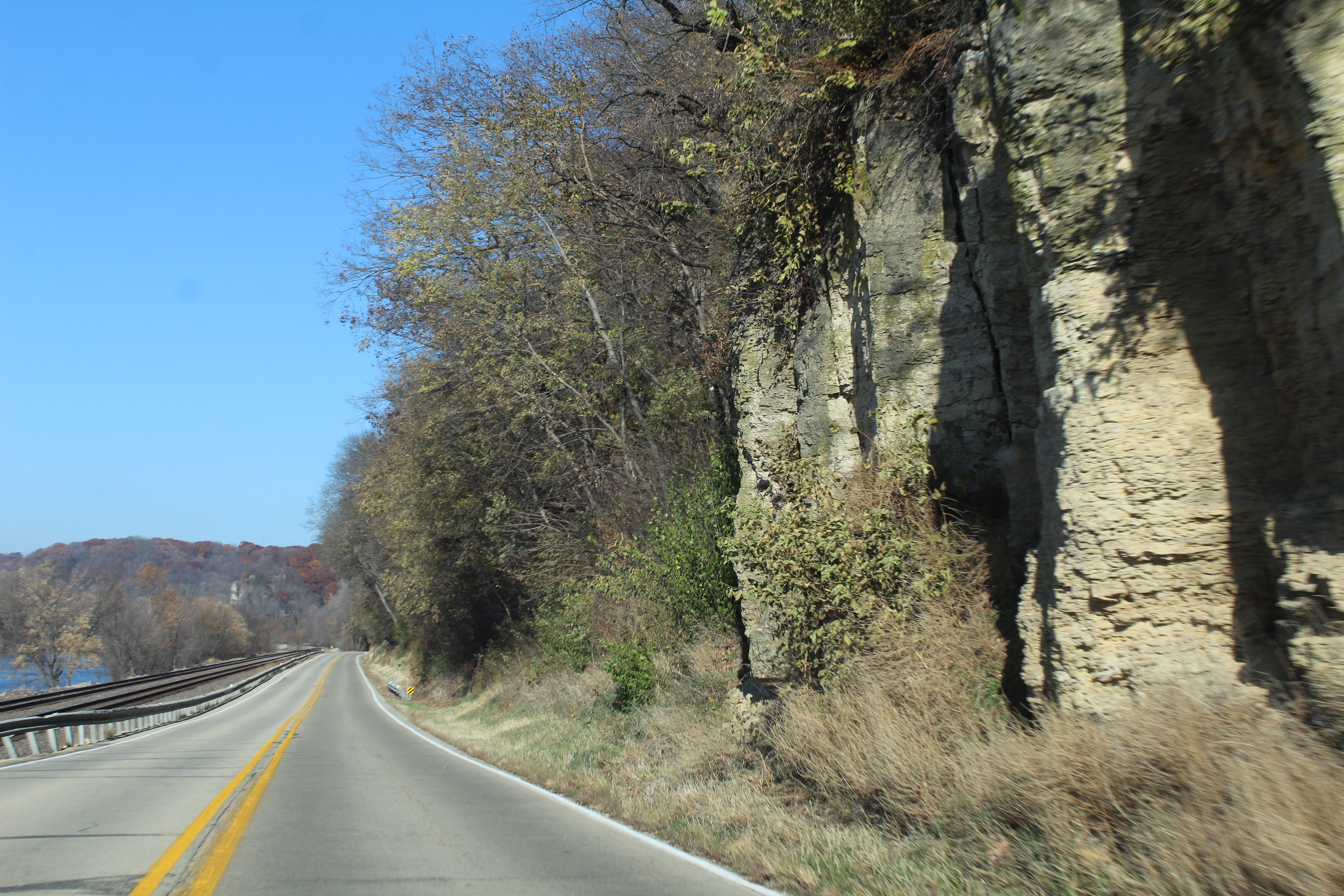
The IHT doesn’t cross the river here, but instead goes north of Route 84, and for a few miles runs along the edge of the Mississippi Palisades (pictured at the top of this page) and its State Park. The park provides plenty of unique views of the river. Other sights to see heading north out of Savanna are an old one-room school house on a hill, the Swampside Farms barn, the former Indian Head Supper Club (the restaurant burned, but the sign remains), the Blackhawk Motel (recently closed), and the Savanna Army Depot site. The former Depot was a federal ammunition storage center and is now an industrial park and prairie preserve.

Hanover and Jo Daviess County
We’re getting closer to our end destination of Galena. Route 84 and the IHT next hits Hanover once across the Jo Daviess County line. The Wapello Land and Water Reserve, listed on the National Register of Historic Places, is on the edge of town – indigenous Late Woodland and Mississippi native tribes united their cultures and settled at this location. Remains of the village are buried at the site.
Entering Hanover, there is a brief alignment change near the old high school where the old IHT follows Savanna Road (a right turn upon entering town), and turns left on Jefferson Street near the St. John the Evangelist church. Follow into downtown. Among the downtown sights is the old Hanover State Bank building. I’ve written in entries past about how bank buildings are usually stately in design – not this one. What’s more intriguing to me is the vintage Michelob beer sign, which is an older version of ones that I have found on other trips.
Route 84 and the IHT curves 90 degrees to the right near a former (but still open) Conoco gas station and an old hotel building. There is a large factory at that curve as well. The road crosses Apple River and there is a large old wood building on the other side to the right. This was the former Hanover Lumber Yard, and until around 10 years ago, the old lettering was still visible; the exterior has since been redone. Just to the west of the bridge is a city street paralleling the river; it has benches that look toward the river and a unique two-level Y-shaped dam (one level is man-made and the other is a natural one.
At the edge of town, there is a backwards-K-like crossing. Route 84 (striped) goes toward Elizabeth. The IHT follows Blackjack Road (follow the sign toward Chestnut Mountain ski resort). Another road leads to the Fergedaboudit Vineyard and Winery. We’ll take the IHT on Blackjack Road 16 miles to Galena, and enjoy the views.
As we head toward Galena, there are several tourist attractions along this path. I’ll forget some of them, but a couple include the aforementioned Chestnut Mountain and the Goldmoor Inn (link).The Winston Tunnel hiking trail also is on this road. The tunnel once served the Chicago Great Western Railroad from 1887 to 1972. Another sight along this road is a collection of large antiques on one’s private property; you’ll find it when you see the old Sears, Roebuck and Co. sign. Another destination is Horseshoe Mound, where you drive up a hill to the top and see spectacular views of the Jo Daviess topography (and very faintly, Sinsinawa Mound in Wisconsin).

When Blackjack Road hits a speed reduction zone, we hit the former community of Bremen. No sign exists there now, but a few houses remain. So why Blackjack Road? It was the name of a nearby lead mine. The road takes a sharp right curve near a mid-1800s brick house, and that’s where the IHT enters Galena – and ends.
The end of the IHT is at a stop sign with U.S. Route 20, which was a stagecoach trail in the 1800s to Chicago. (There is another Chicago-bound stagecoach trail heading northeast of town.) For more on Galena, see my Trip Log about its Visitor’s Center.
I hope you’ve enjoyed the journey!

Very interesting. Cody did you visit the Winston Tunnel ???
LikeLike
I’ve only driven past the entrance. When I’m more mobile to go hiking back there, I can. I hear the grass is very tall around there.
LikeLike