Getting to Chicago different ways
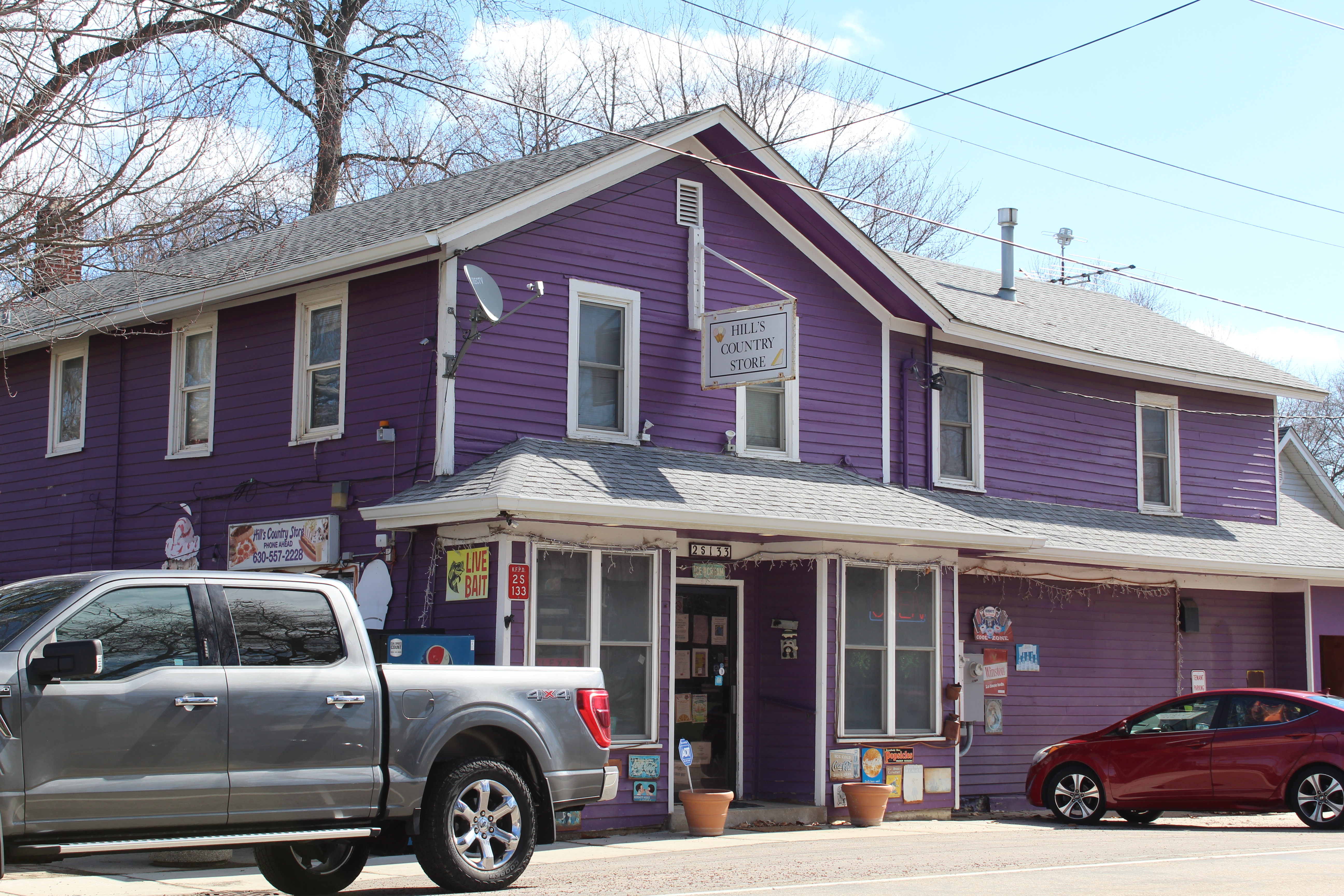
(Pictured: Hill’s Country Store, Kaneville)
I have always said that the best road trips happen when you have an abundance of time on your hands, and not sticking to strict itineraries.
When it comes to Chicago and its metro area, time can be a weird thing to fight against.
When I’m in the city, I limit my trips to one museum a day (two at the very most), and schedule either early breakfasts or late dinners with anyone. If you feel rushed or have time elements on your mind too much, the trip won’t be as fun. I would hate to rush through a museum to make time.
Sometimes making separate trips to museums far from home can be costly, and the allure of bundling them seems like a time saver. But do you really get your money’s worth when you’re fighting time? There are several situations to weigh depending on how you live, and to each their own.
Let me divulge a little about how I live. I work in a job that pays $16 an hour. I pay bills and property taxes, too. Being single, I can get away with altering conveniences whenever I want to, as long as it’s healthy. So when I go on a road trip, I try to have as much time on my hands as I can possibly have. This means I don’t have to travel in express fashion if I don’t want to – namely, expressways.
I used to have an I-Pass when I was young because I thought I would be traveling to the city and suburbs quite a bit, but it wasn’t worth the maintenance of refilling and account checking – plus, it costs money. I figured that if I went on a paralleling route, yes, it would take a little longer, but I’d be saving some money, too. I came to this realization when I was much poorer than today. I could go on the tollway to get there faster, but carving a drive through small towns and suburbs seemed more appealing to me than seeing nothing on the tollway.
Here’s my path to Chicago:
I live in Sterling. I leave Dixon on Illinois Route 38 to Franklin Grove, where I go through downtown and leave town on the southeast side on Reynolds Road. I’ll follow Reynolds Road 11.5 miles to Illinois Route 251, and go north (left) for a mile or so to Perry Road (right). I’ll follow Perry Road for about 30 miles to Kaneville, where I can turn left on Main Street to get into the metro area.
Six miles from Kaneville on Main Street is a roundabout with Fabyan Parkway, where I go left. This Fabyan Parkway stretch of road changes names a couple of times (Washington Street, Geneva Road, St. Charles Road), but goes uninterrupted for 21 miles to Villa Park, where there is a short right-then-left jog under the Union Pacific railroad. Interstate 290 is 4.5 miles away. I could take I-290 to get anywhere on the south side, or I can continue east on St. Charles Road to go anywhere in the middle or on the north part of the city. St. Charles Road ends in Maywood, where I’ll go a half-mile north (left) to Chicago Avenue and turn right – and that goes all the way to Lake Shore Drive.
[Update: After originally posting this, I thought someone would ask me: “Why not just take 38 all the way down?” I actually don’t because I’ve already been through everything I need to see on 38 from Franklin Grove to DeKalb. That’s why. Plus, I actually am contradicting myself a little when I say that the way I take is faster than going through some of the towns on 38, especially Rochelle and DeKalb, but it’s all so close to home for me that they really don’t factor into a dedicated Chicago area trip.]
If I need to go to Aurora, Naperville, Downers Grove, Lemont, Orland Park, etc., I’ll take Main Street past the Fabyan roundabout to Batavia, then Randall Road to Indian Trail Road in Aurora and follow all sorts of different combinations to get to wherever I need to go.
As complicated as this is, there’s always something different to discover along this path – unlike going on the expressways. Yes, it’s much slower, but, again, I think the best road trips are those when time is thrown out the window. Just remember, on the way back, to follow Geneva Road in Glen Ellyn when there’s a fork in the road where St. Charles Road goes right (and where the historic Stacy Tavern is, I visited in 2015).
Best of all, I don’t get to spend money on tolls. Not having an I-Pass, it’s $21.60 round-trip to get to the city from Dixon ($3.60 in Dixon, $3.60 in DeKalb, $1.80 at Farnsworth Ave. and $1.80 at York Road – all multiplied by two). I could either save that $21.60, or support a small business on an unplanned stop along my usual route. You just have to judge for yourself on whether the extra time is worth the savings.
If you just went on the interstate, you wouldn’t know about the Stacy Tavern (one of the first important buildings in Glen Ellyn, now a museum), or even Hill’s Country Store in Kaneville, which was built in 1868 (link to my Facebook post below this). Hill’s building is a purple color, and has everything from desserts and groceries to a box of old 45 records.
But perhaps the real takeaway from going on such a path – or whatever path you wish to carve – is sampling the local cuisine (and I don’t mean Portillo’s). You can’t sample local cuisine off of the interstate with those big name restaurants.
In a world where expedition and convenience rules life, taking road trips on a slower pace creates a more well-rounded experience. Yes, it’s easier to zoom down the expressways, but if you carve the right paths through the suburbs, you discover places that are waiting to meet your appeal. Have a kid who likes toy trains? A mile south of the aforementioned Stacy Tavern in Glen Ellyn is the 2 Toots Train Whistle Grill, a small downtown restaurant where your food is delivered on a toy train track (where I also visited in 2015). But you wouldn’t know that if you simply drove on the interstate.
Take the time. Discover future memories. Taste good food.
Metra: When downtown parking is a hassle and you can walk
I recently took the Metra Pink Line from Elburn to downtown Chicago for a museum stop (Museum of Broadcast Communications – post coming soon) and sightseeing. Not knowing exactly how long I’d be there, and knowing that parking fees are pricy, and needing to save some money, AND needing to start walking more, I decided to take Metra on this instance.
I only took Metra one other time in my life, because I prefer to travel by car. That was for a downtown New Years Eve celebration in the early 2010s. No way I was driving around that. So this really was kind of like a first-time experience for me.
Parking in Elburn is $1.50 for the day. Cheap. The round-trip fare to get from Elburn to Ogilvie Transportation Center in downtown Chicago is anywhere between $7 and $13.50 per person depending on the day, and how tech savvy you are on phone apps (Ventra). Great for a solo traveler like me. Leaving Elburn, you start to see some hobo camps on the side of the tracks before getting into the more expensive suburbs. If you’re not a big phone app person, like me, remember to bring cash when coming from Elburn. That’s when the conductor still punches your ticket. I can’t speak for all of the other end points on the Metra routes, however.
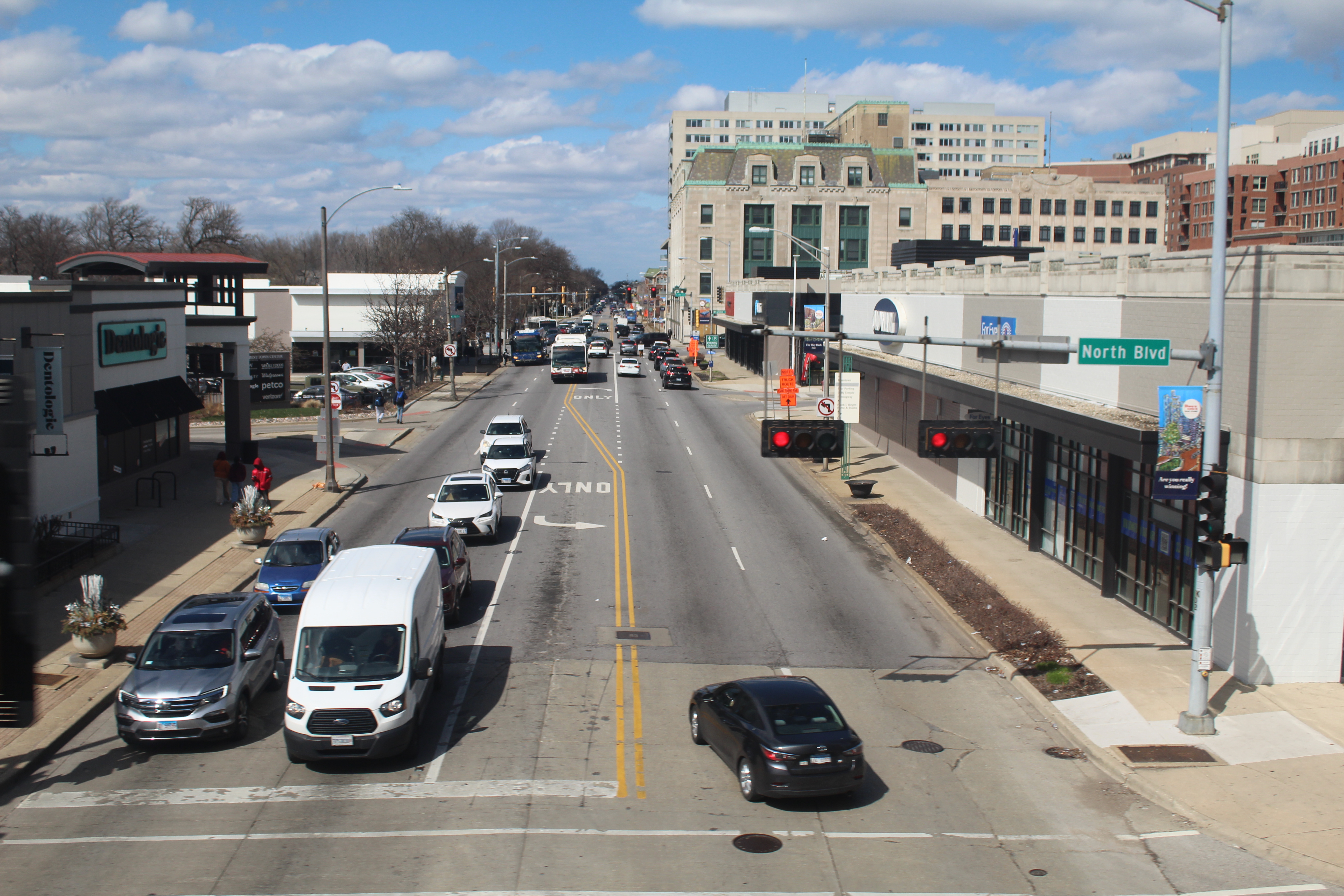
There’s a lot that zooms by, but you do get a nicer view of the Fox River in Geneva than one usually would see (you also get a brief glimpse of the aforementioned 2 Toots Grill, and could stop there if you have a Metra day pass). I experimented with shooting vanishing points and was able to get the image at the bottom of this post of Harlem Avenue in Oak Park.
I have decided that I need to walk more in my daily life. Walking with nothing to see is boring. Walking with something to see, and a memory to have, is multi-tasking.
In fact, I think I can get away with parking in Elburn and only having to walk a net five blocks to get to museums in Kenosha: take the Pink from Elburn to downtown, then the Green from downtown to Kenosha, walk across the parking lot to the Kenosha Street Car system, where it’ll take me to the Kenosha Public Museum, the city’s Civil War Museum or the city’s Dinosaur Museum – three places I wasn’t able to visit when I went to Kenosha last year. No, that’s not a true “road trip,” but rather a “rail trip.” I’d have to pick off one museum at a time in order to make the stops worth it, planning accordingly, because two in a day would create scheduling issues and I don’t want to worry about that when I am roaming a museum.
The best road trips happen when you have an abundance of time on your hands.