In the far northeast corner of Putnam County, there is a small community named Mount Palatine. Not to be confused with Mount Prospect or Palatine.
Just a handful of houses remain in a community that once was home to a college more than 175 years ago: That would be Judson College, not to be confused with the current Judson University in Elgin.
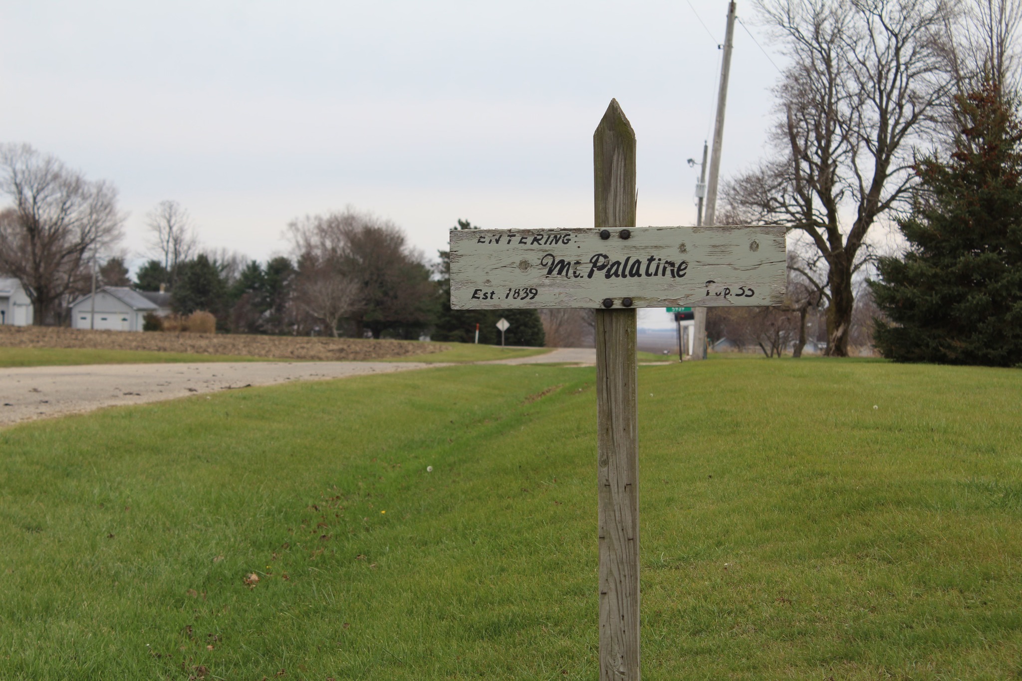
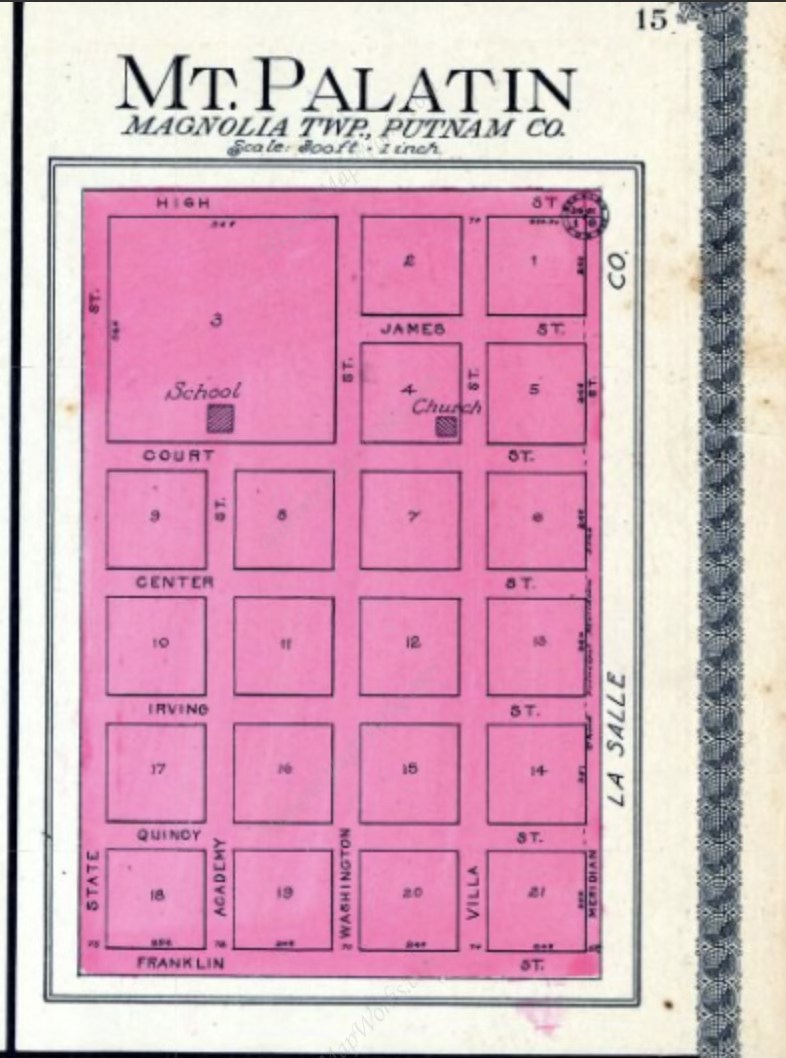
Only a couple of dozen residents remain in the community, whose heyday ceased when the old Judson College went out of business in the late 1850s. A small sign welcoming people to the community sits at one of its entrances. Mount Palatine is about 8 miles south of Peru, and was laid out in a six-by-four street grid of 20 blocks in 1839:
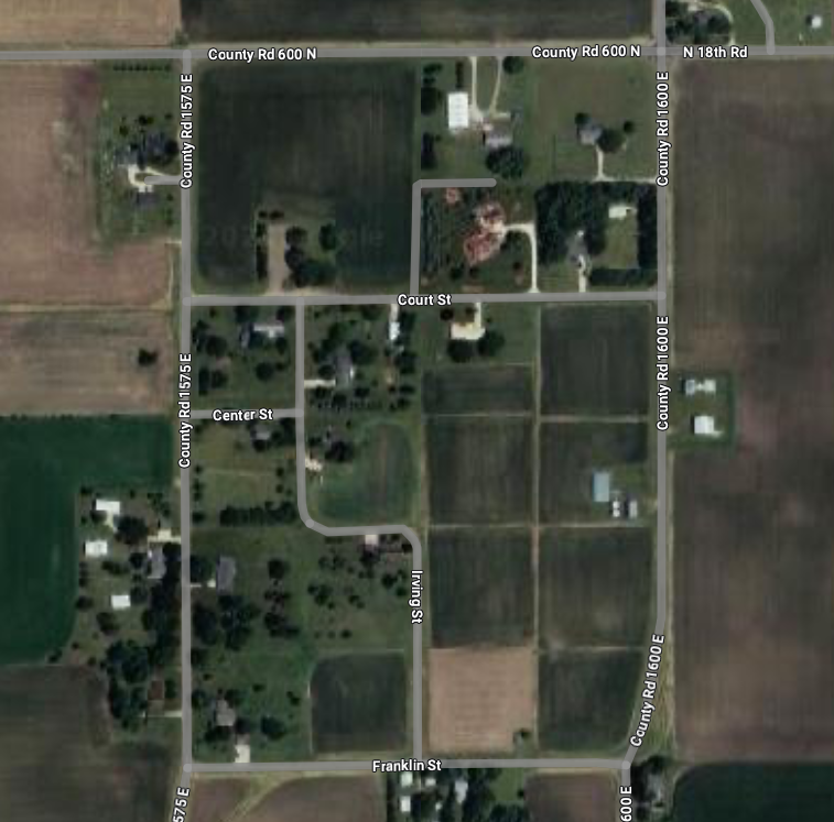
Today, only parts of that street grid remain. The rest has been overgrown and turned into farm or residential land over the many decades. Evidence of its former grid remains, however.
Back when the grid was a nearly full one, the college was Mount Palatine’s symbolic center. It was established in 1846 as the Baptist-run Mount Palatine Academy before its name change. The site later became a Catholic Church, and even that has since been long gone.
Mount Palatine’s actual demise came as a result of failing to catch the railroad – which not just moved people and goods, it moved communities as well. The Illinois Central’s “Gruber Line” from Freeport to Centralia was laid out in the early 1850s, and it bypassed Mount Palatine in favor of nearby Tonica. My phraseology for a community like Mount Prospect is “rail-killed.” When rail lines were laid out, they were meant to go through in the straightest line possible to save money on construction.
With the college gone, and commerce moved elsewhere, Mount Palatine started to fade. Houses disappeared; then some of the streets they were on did as well.
Mount Palatine’s perimeters remain, but only a one-block stretch of Center Street and a S-curve shape of Irving Street also remain. When looking on internet maps, however, paths are still extant where the rest of the streets used to be. Right-of-way foundations remain on those ghost stretches.
There are many instances of former street alignments from more than 100 years ago in towns being totally wiped from visual existence. With these extant visual grids, it gives map viewers the thought of “what once was” in a very tiny rural community. At least it intrigued me!
Some more pictures of Mount Palatine are on my Facebook photo albums. Start HERE and go from there for a few images. Since they are on Facebook, you need to have a Facebook account to view that album.

Thank you for Ghost Grids of Mt. Palatine. Obituary records indicate that my ancient ancestors, the Laughlin family, owned farms nearby beginning in the 1840s. Three generations were active members of the Illinois Anti-Slavery Society who helped enslaved people escape from southern states to Chicago.
https://www.findagrave.com/memorial/92001986/samuel_davis_laughlin
LikeLike
David, I am researching Harriet Ferry Barr (1849-1926), who was adopted by James Gilliland Laughlin and Julia Smith Laughlin sometime in the 1850s. I believe James was the son of Samuel Davis Laughlin, and the family lived in Mount Palatine and later in Princeton, IL. Happy to share info if you want: juliacmead@gmail
LikeLike